
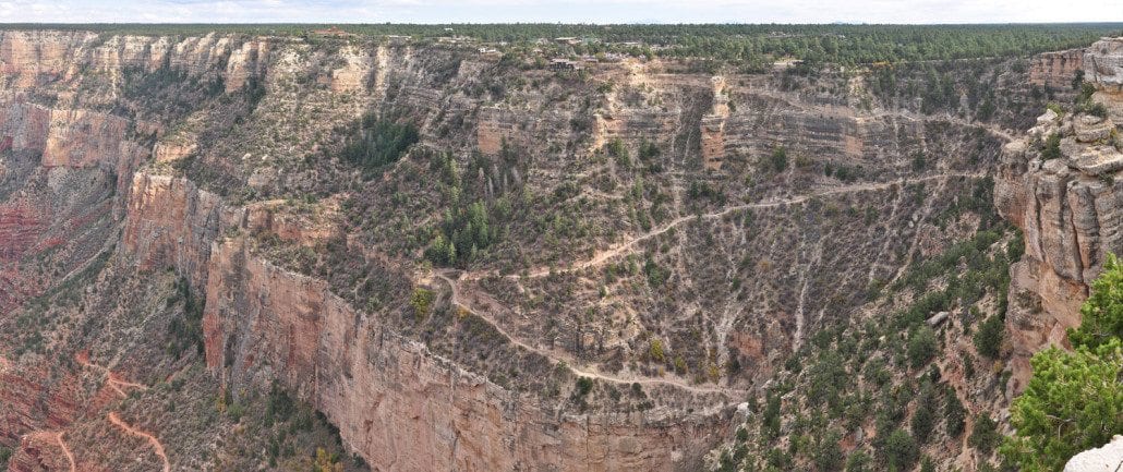
9 Reasons the Bright Angel Trail Is the Grand Canyon’s Most Rewarding — and Most Misunderstood — Hike
Most people who hike Bright Angel Trail think they know what they’re getting into. They’ve seen the photos, read the overview, maybe watched a video or two. Then they step onto the trail, and the canyon does exactly what it has done to visitors for over a century: it rewrites every expectation they brought with them.
Bright Angel Trail is simultaneously the most accessible and the most misunderstood hike on the Grand Canyon South Rim. It welcomes millions of visitors each year, yet it humbles a surprising number of experienced hikers who underestimate its demands. It offers some of the most dramatic geological scenery on the planet, yet many visitors rush through it without recognizing what they’re actually looking at. It has a storied human history that stretches back thousands of years, yet most trail guides reduce it to a mileage chart.
This guide changes that. Below are nine reasons Bright Angel Trail deserves to be understood on its own terms, not just walked. Each reason covers something most visitors either miss entirely or get badly wrong, and each one will change how you experience this trail whether you’re planning your first visit or returning for your fifth.
Before you lace up your boots, consider starting your South Rim adventure at Grand Canyon Visitor Center IMAX, located in Tusayan just outside the South Rim entrance gates. The flagship film “Grand Canyon: Rivers of Time” on a six-story IMAX with Laser screen gives you a geological and cultural orientation that will deepen everything you see on the trail. Book IMAX online and save 20% on tickets.
1. The Trail Follows a Fault Line, and That Changes Everything About the Geology You See
Bright Angel Trail doesn’t cut randomly down the canyon wall, it follows the Bright Angel Fault, a major geological fracture that has shaped the landscape for hundreds of millions of years. This is the single most important fact most hikers don’t know, and understanding it transforms the experience from a walk into a living geology lesson.
A fault line is a zone where rock layers have fractured and shifted relative to each other. The Bright Angel Fault created a natural weakness in the canyon wall that water has been exploiting for millennia. That erosion carved the drainage corridor that made the trail possible in the first place. Without the fault, there would be no accessible route down this section of the South Rim, and the canyon’s interior would remain largely out of reach to foot travelers.
What does this mean for what you actually see on the trail? As you descend, you move through a series of distinct rock formations, each representing a different chapter in Earth’s history. The Kaibab Limestone at the rim, the Toroweap Formation just below it, the Coconino Sandstone (recognizable by its pale, cross-bedded appearance), the Hermit Shale, and then the Supai Group of alternating red sandstones and shales. Each layer was deposited in a radically different environment: ancient seas, coastal tidal flats, vast desert dune fields, river floodplains.
The fault also explains why Bright Angel Creek exists where it does. Water follows zones of weakness in rock, and the fault provided exactly that. The creek has been cutting downward continuously, and its path is why the trail has water sources at Indian Garden (now officially renamed Havasupai Gardens) at the 4.6-mile mark, a rarity in canyon hiking that makes Bright Angel Trail significantly more forgiving than most South Rim alternatives.
How to apply this on the trail: As you descend, pause at each major rock transition and look at the color and texture change. The shift from pale limestone to the reddish Hermit Shale is dramatic and unmistakable. Look for the angular unconformity, a gap in the geological record representing hundreds of millions of missing years, visible where the Tonto Platform meets the Inner Gorge. The National Park Service’s Grand Canyon geology overview is an excellent primer to read before your visit.
Visitors who watch “Grand Canyon: Rivers of Time” at Grand Canyon Visitor Center IMAX before entering the park will recognize these formations by name as they encounter them, turning a physical descent into a genuine geological timeline.
2. The “Turn Around” Decision Is the Most Critical Skill This Trail Tests
More hiking emergencies on Bright Angel Trail result from poor turnaround decisions than from any other single factor. The National Park Service consistently emphasizes this point, yet it remains the most reliably ignored piece of advice on the trail. Understanding why the turnaround matters, and how to make the call correctly, is what separates a rewarding hike from a dangerous one.
The fundamental problem is what rangers call “the canyon inversion effect.” Unlike mountain hikes where the hardest work is on the way up and you’re fresh when it matters most, canyon hiking front-loads the easy part. Going down is deceptively comfortable. The trail descends roughly 4,460 feet from the rim to the Colorado River, and that descent lulls hikers into a false sense of capability. By the time the heat, exertion, and altitude have done their work, you still have to climb all the way back up.
The standard NPS guidance is clear: day hikers should not attempt to hike to the Colorado River and back in a single day. The round-trip distance is approximately 19.5 miles with nearly 4,500 feet of elevation gain on the return. Even for fit, experienced hikers, this is an aggressive undertaking under optimal conditions. In summer heat, it becomes genuinely life-threatening.
The established turnaround points for day hikers are the 1.5-Mile Resthouse (with emergency phones, toilets, and seasonal water) and the 3-Mile Resthouse (with toilets, year-round water, and emergency phones). Havasupai Gardens at 4.6 miles is appropriate for fit, well-prepared hikers on cooler days, but should be approached as a serious destination, not a casual extension.
How to build a turnaround discipline: Set your turnaround time before you start, not based on how you feel when you get there. A useful framework: calculate one-third of your total water and energy for the descent, two-thirds for the ascent and recovery. If you’ve consumed half your water by a certain point, that point is your turnaround regardless of how good you feel. Physical sensation is an unreliable guide in canyon heat, dehydration and heat exhaustion can feel like mild fatigue until they don’t.
Check current Grand Canyon trail conditions with the NPS before your hike, as seasonal water availability at resthouses can affect turnaround planning significantly. The NPS trail conditions and closures page is updated regularly and should be your first stop for current information.
3. Bright Angel Has a Human History That Predates the Park by Thousands of Years
The Bright Angel Trail corridor has been used by humans for at least 4,000 years, and the trail itself follows routes established by the Havasupai people long before any non-Indigenous visitor set foot in the canyon. This history is etched into the landscape in ways most hikers walk right past.
The Havasupai people, whose name translates roughly to “people of the blue-green water,” have lived in and around the Grand Canyon for centuries. They used the corridor now traced by Bright Angel Trail as a seasonal route between the rim and the canyon’s interior, where they farmed and gathered resources. The springs at what was then called Indian Garden, now officially renamed Havasupai Gardens by the NPS in recognition of this heritage, were a central resource for this seasonal occupation.
When the Santa Fe Railway brought tourist traffic to the South Rim in the early 1900s, entrepreneur Ralph Cameron recognized the trail’s commercial potential. He filed mining claims along the route specifically to control access and charge a toll, a practice that generated significant legal conflict with the NPS and the state of Arizona over more than two decades. The federal government eventually prevailed, and the trail was incorporated into the park’s public infrastructure, but not before Cameron’s opportunistic claims had shaped the early development of the South Rim’s tourist infrastructure in ways that still echo today.
The original Garden Creek campsite and orchard at Havasupai Gardens date to this early tourism era. The cottonwood trees that provide welcome shade at the 4.6-mile rest area were planted during this period and have grown into a genuine riparian oasis that supports wildlife found nowhere else along the trail.
How to engage with this history on the trail: Look for the interpretive signage at the trailhead near the Grand Canyon South Rim visitor center inside Grand Canyon Village, which covers both Indigenous use and the early tourism era. At Havasupai Gardens, the ranger station and historic structures are visible reminders of the site’s long occupation. Taking a moment to acknowledge the site’s original name and its meaning adds a dimension to the hike that purely physical engagement cannot provide.
4. Wildlife Encounters Are Common, and Commonly Mishandled
Bright Angel Trail passes through multiple distinct ecological zones, each supporting different wildlife communities, and the animals hikers encounter are genuinely wild, not habituated display animals. How you handle these encounters affects both your safety and the long-term health of the canyon’s wildlife populations.
The most frequent encounters involve California condors near the rim, mule deer along the upper and middle sections of the trail, rock squirrels throughout the corridor, and ringtail cats near the resthouses (primarily nocturnal, but occasionally spotted by early-morning hikers). Less commonly seen but present in the canyon are coyotes, bobcats, and various species of lizard including the impressive collared lizard.
The condor deserves special attention. California condors were reintroduced to the Grand Canyon region beginning in 1996 after the species was reduced to just 27 individuals in the wild. Current populations in the region number in the dozens, making the South Rim one of the most reliable places in North America to see these birds in flight. Their wingspan can exceed nine feet, and watching them ride thermals above the canyon is one of those genuinely rare wildlife experiences that doesn’t require any special effort to access, they’re often visible from the trailhead area itself.
The rock squirrels are the animal most likely to cause problems. They are bold, persistent, and have learned to associate hikers with food over generations of visitor contact. Feeding them, even inadvertently by leaving food unattended, is harmful to the animals and is prohibited by park regulations. A squirrel that has become food-conditioned loses its ability to forage naturally and becomes increasingly aggressive toward visitors.
Practical wildlife protocol: Keep a distance of at least 100 feet from large mammals. Never feed any wildlife. Store food in sealed containers, not just zipped packs, as squirrels will chew through fabric. If condors land near you (they sometimes do at the rim), resist the urge to approach, observe from where you are and report any banded birds to the park’s condor team if possible. For detailed guidance, the NPS Grand Canyon wildlife page covers each major species and appropriate visitor behavior.
For wildlife tips specific to the canyon’s geological zones, the article on Grand Canyon wildlife watching facts and tips covers practical observation advice worth reading before your hike.
5. Water Is Available, But That Availability Creates a False Sense of Security
Bright Angel Trail is one of the few Grand Canyon hikes with reliable water sources mid-route, but this relative abundance has a downside: hikers routinely underpack water because they assume they can resupply freely. Understanding exactly how and when those water sources operate is essential to safe planning.
The trail has three primary water sources: the 1.5-Mile Resthouse, the 3-Mile Resthouse, and Havasupai Gardens at 4.6 miles. The 1.5-Mile and 3-Mile Resthouses have water available roughly from mid-May through mid-October, the exact dates vary by year based on NPS operational decisions. Outside those months, these sources are turned off. Havasupai Gardens has year-round water, but reaching it requires a 9.2-mile round trip with significant elevation change, which is not a casual extension.
The practical planning implication is this: if you’re hiking between late October and mid-May, treat the upper resthouses as dry and carry everything you need from the rim. Even in summer, carry at least one liter per person from the trailhead and plan to refill rather than depend on resupply. The NPS recommends a minimum of one liter of water per hour of hiking in summer conditions, which is substantially more than most recreational hikers typically carry.
Electrolyte balance is equally important. Drinking large quantities of plain water without replacing sodium and other electrolytes can lead to hyponatremia, a dangerous condition that mimics heat exhaustion but is worsened by drinking more water. Salty snacks, electrolyte tablets, or sports drinks consumed alongside water help prevent this. The NPS specifically warns against drinking only water on long summer hikes for exactly this reason.
Water planning framework for Bright Angel Trail:
| Turnaround Point | Round-Trip Distance | Minimum Water (Summer) | Water Available En Route? |
|---|---|---|---|
| 1.5-Mile Resthouse | 3 miles | 2 liters per person | ⚠️ Seasonal (mid-May–mid-Oct) |
| 3-Mile Resthouse | 6 miles | 4 liters per person | ⚠️ Seasonal (mid-May–mid-Oct) |
| Havasupai Gardens | 9.2 miles | 6 liters per person | ✅ Year-round |
| Colorado River | 19.5 miles | Overnight required | ✅ Multiple sources |
Before your hike, verify current water availability at the Grand Canyon South Rim visitor center inside the park at Grand Canyon Village, or check the NPS website. The hiking gear retail store at Grand Canyon Visitor Center IMAX in Tusayan stocks hydration bladders, electrolyte supplements, and other trail essentials if you need to gear up before entering the park.
6. The Trail’s Mule Traffic Has Rules, and Hikers Who Don’t Know Them Create Hazards
Bright Angel Trail is one of the few hiking trails in the US National Park system that shares its corridor with commercial mule trains, and the protocol for these encounters is both legally required and genuinely important for safety. Most first-time visitors are caught off-guard by this dynamic.
The Grand Canyon’s mule operations have been running continuously since the late 1800s, making them one of the longest-running commercial visitor services in any national park. Mule trains carry both passengers and supplies (including food and equipment for Phantom Ranch at the canyon bottom), and they use Bright Angel Trail as their primary corridor. On any given day, you may encounter mule trains descending in the morning and ascending in the afternoon.
The established protocol when encountering a mule train is straightforward but non-negotiable: hikers must step to the uphill side of the trail and remain still and quiet until the entire train has passed. This isn’t arbitrary trail etiquette, it’s a safety requirement. Mules are prey animals with strong flight responses. A sudden movement or sound can startle an animal carrying a passenger on a narrow trail with significant exposure, with potentially serious consequences.
“Step to the uphill side” is the specific instruction because stepping to the downhill side puts you in a more dangerous position if an animal shies. The uphill side keeps you against the rock face rather than near the edge. Wait for the wrangler (who rides last in the train) to pass before resuming your hike, and follow any specific instructions the wrangler gives, they may ask you to speak calmly to reassure the animals or to wait an additional moment.
Mule trains typically move at a pace that feels slow to hikers, but they have the right of way on the trail. Planning your hike with mule traffic in mind means being aware that the busiest mule traffic windows on Bright Angel Trail are typically early morning (descending) and mid-to-late afternoon (ascending). If you’re on the trail during these windows, expect to yield multiple times.
What most guides don’t tell you: The mule operations also give you a useful real-time read on trail conditions. Wranglers on the trail every day know the current state of the surface, water availability, and weather patterns better than almost anyone. If you pass a wrangler going in the same direction and have an opportunity to ask a quick question, they’re often willing to share current conditions. Treat it as a brief exchange, not a lengthy conversation, as they have animals and passengers to manage.
7. Seasonal Timing Changes the Trail More Dramatically Than Any Other Variable
Bright Angel Trail in July and Bright Angel Trail in January are, in practical terms, two completely different experiences, different hazards, different scenery, different crowds, and different physical demands. Choosing the right season for your ability level is one of the most consequential decisions you’ll make in planning this hike.
Summer (June through August) brings the highest visitor volumes and the most dangerous conditions. Rim temperatures in the mid-80s to low 90s translate to temperatures well above 100°F on the inner canyon trails where there is little shade and the rock radiates heat. The NPS issues heat warnings during this period and strongly discourages hiking below the rim between 10 AM and 4 PM. Hikers who ignore this guidance account for the majority of heat-related emergencies the park responds to each year. If you visit in summer, start before sunrise, reach your turnaround point by mid-morning, and be back at the rim before midday.
Spring (March through May) and fall (September through November) are the most popular windows for experienced canyon hikers. Temperatures are more moderate, the trail is less crowded than summer, and the light quality at both ends of the day is exceptional for photography. Spring brings the possibility of wildflowers along the Tonto Platform near Havasupai Gardens. Fall offers the cottonwood trees at Havasupai Gardens turning gold, one of the most underrated visual moments on the entire trail.
Winter (December through February) is the genuinely surprising option. The canyon is far less crowded, and the upper sections of the trail frequently have snow and ice that create a completely different visual environment. Ice on the trail requires microspikes or similar traction devices, this is not optional on the switchbacks near the rim, which become genuinely treacherous when iced. Below the snowline (roughly the 3-Mile Resthouse level in most winters), conditions often return to dry and mild. Winter hiking rewards those who prepare properly with some of the most dramatic canyon scenery available: snow-dusted canyon walls, low-angle winter light, and near-solitude on a trail that in summer feels like a crowded boulevard.
Seasonal comparison at a glance:
| Season | Primary Hazard | Crowd Level | Best For | Key Prep Item |
|---|---|---|---|---|
| Summer | Extreme heat | Very high | Early-morning short hikes only | Extra water, electrolytes, sun protection |
| Spring | Afternoon thunderstorms (May) | Moderate–High | All ability levels | Rain layer, flexible timing |
| Fall | Rapid temperature drops | Moderate | Experienced hikers, photographers | Layers, early starts |
| Winter | Ice on upper trail | Low | Fit hikers seeking solitude | Microspikes, warm layers, headlamp |
Regardless of season, checking current conditions is essential. The NPS updates Grand Canyon trail conditions reports regularly, and conditions can change within a single day during monsoon season or winter weather events. Plan your visit by consulting the official NPS resources, and if you’re arriving by vehicle and want to avoid the park entrance line, picking up your National Park pass at Grand Canyon Visitor Center IMAX in Tusayan before entering saves meaningful time at the gate.
8. The Trailhead Area Is More Complicated Than Most Maps Show
Finding and accessing the Bright Angel Trailhead involves navigating a transportation system that confuses a significant portion of first-time visitors, and the confusion often costs time that would be better spent on the trail. Getting this logistics piece right before you arrive removes one of the most common sources of frustration at the South Rim.
The Bright Angel Trailhead is located at the western end of Grand Canyon Village, adjacent to the historic Bright Angel Lodge. It is not in the main visitor center area, and it is not accessible by private vehicle during peak season, parking in Grand Canyon Village fills extremely early, often before 7 AM in summer, and the lot immediately adjacent to the trailhead is reserved for lodge guests and permit holders.
The practical solution is the South Rim’s free shuttle bus system, which the NPS operates with multiple color-coded routes. The Village Route (blue) and the Hermits Rest Route (red) both service stops near the Bright Angel Trailhead. The most useful strategy for hikers is to park at the South Rim Visitor Center parking area (the largest lot in the park) and take the shuttle to the trailhead. This is actually faster and less stressful than hunting for trailhead parking, particularly on high-traffic days.
Alternatively, and this is the option many visitors don’t consider, arriving via the Tusayan shuttle from just outside the park eliminates the parking problem entirely. The Tusayan shuttle service runs from Tusayan into the park and is a genuinely practical option for visitors staying or stopping in Tusayan. It deposits passengers near the visitor center hub from which shuttle connections to the trailhead are straightforward.
The Grand Canyon South Rim visitor center inside the park at Grand Canyon Village, distinct from the privately operated Grand Canyon Visitor Center IMAX in Tusayan, offers a ranger station where you can ask about current trailhead conditions, get a paper trail map, and confirm shuttle timing. Rangers there can also advise on whether the mule operations have any schedule changes that might affect your planned hiking window.
Trailhead logistics checklist:
- Arrive at the South Rim before 7 AM if driving in peak season, or use the shuttle system
- Pick up your National Park pass before arrival at Grand Canyon Visitor Center IMAX in Tusayan to skip the entrance gate line
- Confirm the current shuttle schedule, routes and timing vary by season
- Download the NPS Grand Canyon app before you lose cell signal inside the park
- Check the trailhead register board for current conditions before descending
- Note the location of the nearest emergency phone (1.5-Mile Resthouse) before you start
For hikers who want a guided experience that removes all logistics pressure, Pink Jeep Tours, with its office at Grand Canyon Visitor Center IMAX in Tusayan, offers guided options that pair the IMAX film experience with canyon exploration. Every Pink Jeep Tour originating from the facility includes a ticket to “Grand Canyon: Rivers of Time,” making it an efficient way to get both orientation and guided access in a single booking.
9. What You See Is Determined Almost Entirely by How Slowly You Move
Bright Angel Trail rewards the deliberate hiker and offers relatively little to the hiker in a hurry. This sounds obvious, but the structure of the trail, a clearly marked, maintained path with identifiable landmarks, actively encourages speed. Most visitors treat it as a route to cover rather than an environment to inhabit, and they finish the hike having missed most of what makes it genuinely extraordinary.
Consider what a hurried hiker misses. The fossil record embedded in the Kaibab Limestone near the rim includes marine invertebrate fossils, crinoids, brachiopods, and sponges, visible in the trail surface and adjacent rock faces if you know to look. These are the remains of creatures that lived in a warm inland sea that covered this region roughly 270 million years ago. They are not behind glass in a museum. They are literally under your feet.
At the Coconino Sandstone layer (roughly 1,500 feet below the rim), the cross-bedding visible in the pale cliff faces represents ancient sand dunes fossilized in stone. The angle of the cross-beds indicates the direction of prevailing winds from the period of deposition, meaning you can read the direction of ancient desert winds in the rock face. This is not a metaphor, it is actual directional data preserved in stone.
The transition from the Supai Group to the Redwall Limestone is one of the most dramatic color shifts on the trail. The Redwall is actually gray limestone that has been stained red by iron oxides washing down from the formations above it. Chip away a small piece of Redwall (which you shouldn’t, it’s a protected resource, but the point stands) and the interior would be gray. The entire iconic red color of this formation is a surface staining, not the rock’s true color.
Beyond geology, slow movement increases wildlife encounters dramatically. Condors are more likely to interact with stationary or slow-moving hikers. Rock squirrels, while habituated, reveal interesting social behaviors when observed over time rather than hurried past. The riparian zone at Havasupai Gardens, with its cottonwood canopy and creek-side vegetation, supports birds, insects, and amphibians that simply aren’t visible at pace.
The 50/10 method for Bright Angel: Walk for 50 minutes, stop for 10. During your 10-minute stop, don’t check your phone. Look at the rock face directly adjacent to you. Look at the view from your current elevation (which changes dramatically with every few hundred feet of descent). Listen for canyon wrens, their descending call is one of the most distinctive sounds in the American Southwest and is present on this trail in every season. This rhythm also happens to be excellent for managing body temperature and hydration.
The experience of watching the canyon’s layers reveal themselves as you descend, moving literally through time at a rate of roughly one million years of geological history per hundred feet of elevation change, is available to anyone willing to move at the pace the landscape deserves. The canyon has been here for five to six million years. It has no interest in your schedule.
If you want to understand what you’re looking at before you step onto the trail, watching “Grand Canyon: Rivers of Time” at Grand Canyon Visitor Center IMAX in Tusayan is the most efficient way to build the visual vocabulary that makes slow hiking rewarding rather than disorienting. The six-story IMAX with Laser screen conveys the scale and geological context of the canyon in a way that text and photographs simply cannot match. Start your Grand Canyon adventure with IMAX and every deliberate pause on Bright Angel Trail will mean more.
Frequently Asked Questions About Bright Angel Trail
How difficult is the Bright Angel Trail for beginners?
Bright Angel Trail is accessible to beginners at its upper sections, but difficulty increases significantly with distance. The first 1.5 miles to the resthouse are manageable for most reasonably fit adults. Beyond that point, the trail demands genuine physical preparation, proper gear, and careful judgment about turnaround timing. No section of the trail below the rim should be treated as casual walking, particularly in warm weather.
What is the best time of day to start the hike?
Sunrise or just before it is the optimal start time for any Bright Angel hike. Starting early gives you the coolest temperatures, the best light for photography, and the best chance of completing your descent and most of your ascent before midday heat sets in. In summer, starting after 8 AM for anything below the first resthouse is actively discouraged by the NPS.
How long does it take to hike to the 3-Mile Resthouse and back?
For a fit adult hiker at a moderate pace, the round trip to the 3-Mile Resthouse takes approximately 4 to 5 hours. This includes time at the resthouse for rest and water. Factor in additional time if hiking with children, in hot weather, or if you plan to spend time looking at the geology and views rather than covering distance quickly.
Is a permit required to hike Bright Angel Trail?
No permit is required for day hiking on Bright Angel Trail. Overnight camping at Havasupai Gardens Campground or Bright Angel Campground (near Phantom Ranch) requires a backcountry permit, which must be obtained through the NPS permit system. Demand for overnight permits is extremely high and reservations should be made months in advance.
What should I wear on the Bright Angel Trail?
Wear moisture-wicking, quick-dry clothing rather than cotton, which retains sweat and causes chilling on the ascent. Sun protection is essential: a wide-brimmed hat, UV-rated sunglasses, and sunscreen applied before you start. Footwear should have ankle support and a grippy sole, trail runners or hiking boots both work, but sandals and flip-flops are inadequate for the uneven terrain. In winter, bring microspikes for the upper switchbacks.
Can I bring my dog on the Bright Angel Trail?
Dogs are not permitted on Bright Angel Trail or any trail below the rim in Grand Canyon National Park. This is a firm NPS regulation, not a recommendation. Kenneling services are available in Tusayan for visitors who travel with pets.
What are the current Grand Canyon trail conditions and how do I check them?
The NPS updates trail conditions on their official website at nps.gov/grca. You can also call the park’s recorded information line or speak with rangers at the visitor center inside the park. Conditions on Bright Angel Trail can change rapidly with weather, so checking within 24 hours of your planned hike is worthwhile, particularly in winter and during monsoon season (July through September).
Where exactly does the Bright Angel Trail start?
The trailhead is at the western end of Grand Canyon Village, adjacent to Bright Angel Lodge on the South Rim. It is accessible via the NPS shuttle system from the main visitor center parking area. Driving directly to the trailhead and finding parking is difficult or impossible during peak season, using the shuttle is the recommended approach.
Is the Bright Angel Trail part of the best hikes on the Grand Canyon South Rim?
Bright Angel Trail is widely considered the most complete day hiking experience on the South Rim because it combines accessible entry, water availability, geological diversity, and historical significance in a single corridor. South Kaibab Trail offers more dramatic open views but has no shade and no water sources, making it a better descent-only option for experienced hikers doing a point-to-point route. Hermit Trail provides more solitude but is unmaintained and significantly more demanding. For most visitors, Bright Angel Trail is the right starting point for South Rim hiking.
Should I watch the IMAX film before or after hiking?
Watching “Grand Canyon: Rivers of Time” at Grand Canyon Visitor Center IMAX before hiking gives you the most value. The film introduces the geological formations, the canyon’s ecological zones, and the human history of the corridor in a way that makes everything you see on the trail more meaningful. Visitors who watch it after hiking often say they wish they had seen it first. The facility is located in Tusayan just outside the South Rim entrance, making it a natural first stop before you enter the park.
What food and gear can I get near the trailhead?
Inside the park, Bright Angel Lodge has a small café and a gift shop. For a more comprehensive selection of hiking gear, snacks, and trail supplies, the retail store at Grand Canyon Visitor Center IMAX in Tusayan stocks a wide range of hiking essentials. On-site dining at the facility includes Pizza Hut Express and Explorers Café, and it’s a practical stop for stocking up before entering the park.
What makes Bright Angel Trail different from other canyon hikes?
The combination of a maintained trail surface, reliable mid-route water sources (seasonal), NPS ranger presence, and multiple logical turnaround points makes Bright Angel Trail uniquely forgiving for hikers of varying experience levels. Its geological diversity, moving through multiple named rock formations over a single descent, also makes it one of the most educationally rich hikes in the US national park system. No other trail on the South Rim offers the same combination of accessibility and depth.
Key Takeaways for Your Bright Angel Trail Hike
- The trail follows a geological fault line, understanding this transforms everything you see from scenery into story.
- The turnaround decision is the most critical skill, set your turnaround point before you start, and don’t let how you feel override it.
- The trail has deep Indigenous history, Havasupai Gardens was a long-occupied seasonal home, not just a rest stop, and the trail follows routes thousands of years older than the park itself.
- Wildlife encounters require specific protocols, particularly for mule trains (step uphill, stay still) and for rock squirrels (never feed them).
- Water availability varies by season, the upper resthouses are seasonal, not year-round, and summer demands far more water than most hikers carry.
- Mule trains have the right of way, step to the uphill side, remain still and quiet, and wait for the wrangler to pass.
- Seasonal timing changes the trail fundamentally, summer demands pre-dawn starts and short distances; winter demands traction devices and layering.
- Trailhead logistics require advance planning, parking fills early, shuttles are the practical solution, and picking up your park pass in Tusayan before entering saves time.
- Slow movement is what the trail rewards, fossils, cross-bedded sandstone, color transitions, and wildlife are all available to the deliberate hiker and invisible to the hurried one.
- Start your trip at Grand Canyon Visitor Center IMAX in Tusayan, the “Grand Canyon: Rivers of Time” IMAX film gives you geological and cultural context that makes every moment on the trail more meaningful. Book online and save 20% on IMAX tickets.

About the author
Explore The Canyon Editorial Team
See The Canyon

