
Grand Canyon Geology Explained: Why Five Million Years of Rock Tell a More Dramatic Story Than Any Postcard
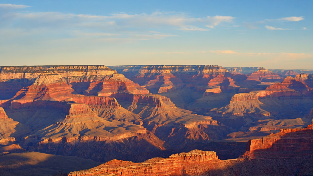
Stand at the South Rim on a clear morning, and the Grand Canyon does something unusual: it refuses to be summarized. You can look at it for ten minutes, twenty, an hour, and the scale simply will not resolve into anything your brain already knows. The colors shift as the sun climbs. Shadows that looked like flat bands reveal themselves as sheer thousand-foot walls. A river you can barely see at the bottom is actually wider than a four-lane highway. And underneath all of it, layer after layer after layer of rock, each one a chapter in a story that stretches back nearly two billion years.
Most visitors experience that moment of overwhelm and reach for a postcard. The postcard is beautiful. But it flattens five million years of active carving, nearly two billion years of geological accumulation, and centuries of human presence into a single image that, honestly, tells you almost nothing about what you’re actually looking at.
This article is about what the postcard leaves out. Understanding Grand Canyon geology history, the cultural forces that shaped how humans have related to this landscape, and the specific viewpoints where all of it becomes visible, changes the experience from a photo opportunity into something genuinely transformative. By the time you’re done reading, you’ll look at those rock layers differently. And if you’re planning a trip, you’ll know exactly how to make the most of every hour you spend at the South Rim.
The Two-Billion-Year Basement: Where the Canyon’s Story Actually Begins
The oldest rocks visible in the Grand Canyon sit at the very bottom of the inner gorge, and they are almost incomprehensibly ancient. The Vishnu Schist, a dark, twisted metamorphic rock that lines the Colorado River corridor, formed roughly 1.7 to 1.8 billion years ago. To put that in context: the Earth itself is about 4.5 billion years old, which means these rocks are nearly half the age of the planet. When they formed, there was no complex life on Earth. No fish. No plants. No oxygen-breathing atmosphere of any meaningful kind.
The Vishnu Schist didn’t start as schist. It began as a combination of sedimentary and volcanic rock that was then buried deep within the Earth, subjected to enormous heat and pressure, and essentially cooked and compressed into the dense, layered crystalline rock visible today. Threading through it in streaks of pink and gray is the Zoroaster Granite, formed when molten rock intruded into the schist and slowly cooled underground. Together, these two rock types form what geologists call the Vishnu Basement Rocks, and they are the foundation on which everything else at the Grand Canyon rests.
What’s remarkable is that these basement rocks are also the site of one of geology’s great mysteries: the Great Unconformity. Above the Vishnu Schist, there is a dramatic gap in the rock record. Somewhere between 1.2 billion and 500 million years of geological history is simply missing. The rocks that should document that enormous stretch of time either were never deposited, or were deposited and then completely eroded away before the next layer formed on top. When you look at the canyon wall and see those dark basement rocks meeting the lighter sedimentary layers above them, you are looking at one of the most significant unsolved puzzles in Earth science. A United States Geological Survey examination of the Great Unconformity continues to be a subject of active geological research, with recent work suggesting a global glaciation event may have driven the erosion responsible for the gap.
For visitors, this matters because it reframes what the canyon is. It’s not just a big hole. It’s a physical archive, and it has gaps, just like any archive. Standing at the rim and knowing that the rocks below you contain a hole in time that spans hundreds of millions of years gives the view an intellectual weight that no photograph can convey.
Reading the Layers: A Floor-by-Floor Guide to Canyon Time
Above the Vishnu Basement Rocks, the Grand Canyon’s walls rise through a sequence of sedimentary layers that are so well-preserved and so clearly defined that they became one of the foundational teaching tools in the history of geology. Each layer represents a distinct environment, a distinct era, and a distinct set of conditions on the surface of the ancient Earth.
The Grand Canyon Supergroup: The Middle Chapter That Almost Disappeared
Just above the basement rocks, in certain parts of the canyon, you can find tilted, older sedimentary layers known collectively as the Grand Canyon Supergroup. These rocks, deposited roughly 700 million to 1.25 billion years ago, are fascinating for two reasons. First, they contain some of the earliest evidence of microbial life found anywhere in the American Southwest, including fossilized stromatolites, which are layered mats built by ancient cyanobacteria. Second, they are not horizontal. They were tilted by ancient tectonic activity and then eroded before the overlying layers were deposited flat on top of them. This creates a visible angular unconformity in the canyon wall, another gap in the record, but this one you can actually see as an angled boundary between tilted and flat-lying rocks.
The Supergroup is not visible from every viewpoint, which is part of what makes certain overlooks more rewarding for geology enthusiasts. Hopi Point and Desert View are among the locations where these older, tilted layers are visible in the canyon walls below the main horizontal sequence.
The Paleozoic Stack: The Layers Everyone Photographs
The broad horizontal bands that define the classic Grand Canyon postcard image are almost entirely Paleozoic-era sedimentary rocks, deposited between roughly 270 million and 525 million years ago. From bottom to top, the major formations are:
- Tapeats Sandstone: A coarse, brown sandstone deposited in shallow marine and beach environments around 505 million years ago. It forms the first major ledge above the inner gorge and is one of the layers hikers encounter early on the Bright Angel Trail.
- Bright Angel Shale: A greenish-gray shale deposited in a shallow sea. Its softer composition means it erodes into gentler slopes rather than dramatic cliffs, creating the wide Tonto Platform visible from the rim.
- Muav Limestone: Deposited as the sea deepened. Limestone forms when calcium carbonate settles in calm marine water, often built up by the shells and skeletons of marine organisms.
- Temple Butte Formation: A formation visible in certain areas of the canyon, representing a period of shallow streams and lagoons after the sea retreated temporarily.
- Redwall Limestone: One of the most visually striking formations in the canyon. This massive, nearly vertical cliff-forming limestone appears to be red, but its actual color is gray. The red color comes from iron oxide staining that has washed down from the Supai Group above it. The Redwall Limestone forms one of the most significant barriers on trail routes and is a critical landmark for hikers.
- Supai Group: A sequence of red sandstones and mudstones deposited in river, coastal, and shallow marine environments. This is the rock that stains the Redwall below it and gives many canyon walls their warm, brick-red tones.
- Hermit Formation: A reddish-brown shale and siltstone layer deposited by ancient rivers and streams in what was a floodplain environment. It forms slopes rather than cliffs and is home to numerous fossil tracks of early reptiles and amphibians.
- Coconino Sandstone: Perhaps the most visually dramatic layer in the upper canyon walls. This pale cream to white sandstone was deposited as wind-blown desert dunes roughly 275 million years ago. The cross-bedding patterns visible in this layer, angled lines within the rock itself, are fossilized dune faces, preserved at the exact angle the dunes stood when they were buried. Footprint fossils found in the Coconino include tracks from ancient reptile-like animals crossing those desert dunes.
- Toroweap Formation: A transitional layer of sandstone, limestone, and mudstone representing a coastline environment as the sea returned.
- Kaibab Formation: The topmost rock layer at the Grand Canyon, the one you are literally standing on at the South Rim. This cream-colored limestone was deposited in a warm, shallow sea roughly 270 million years ago and contains fossils of sponges, corals, brachiopods, and other marine organisms. The fact that you are standing on ancient seafloor at an elevation of more than 7,000 feet above sea level is one of geology’s most striking demonstrations of how dramatically the Earth’s surface can change over time.
Understanding these layers gives every overlook a completely different meaning. You’re not just looking at color bands. You’re reading a sequence of ancient environments, each one representing millions of years of conditions on a planet that looked almost nothing like the one we inhabit today.
How the Canyon Was Actually Cut: Five Million Years of River Power
The Colorado River began carving the Grand Canyon roughly five to six million years ago, though the debate around the precise timing remains active in geological circles. What is clear is the mechanism: the river, fed by snowmelt from the Rocky Mountains and carrying an enormous sediment load, cut downward through the rock as the Colorado Plateau slowly rose due to tectonic forces. The combination of a river cutting down and a landscape rising up is what created the canyon’s extraordinary depth relative to its surroundings.
The process is called incision, and the Colorado River was extraordinarily efficient at it. The river used its sediment load like sandpaper, grinding through rock layer after layer. Harder rocks like the Kaibab Limestone and Redwall Limestone resisted erosion and formed vertical cliffs. Softer rocks like the Bright Angel Shale eroded more quickly, forming the wide platforms and slopes visible between cliff bands. This alternating pattern of resistant and soft rock is what gives the canyon its characteristic stepped profile rather than a simple V-shape.
Side canyon formation was driven by a different process: tributary erosion and mass wasting. Streams flowing into the main canyon from the plateau above cut their own side canyons, while rockfalls and slumping continually widened the walls. The result is the labyrinthine network of side canyons, buttes, temples, and mesas that makes the Grand Canyon’s interior a landscape of almost infinite complexity. Features like Brahma Temple, Zoroaster Temple, and Cheops Pyramid are not mountains. They are isolated remnants of the plateau surface, left standing as the canyon widened around them.
The Colorado River today is dramatically different from the river that did most of this carving. The construction of Glen Canyon Dam upstream in the 1960s transformed the river from a turbid, sediment-heavy, seasonally flooding waterway into a relatively clear, cold, controlled stream. The dam stopped most of the sediment supply that once drove active erosion. The canyon as it exists today is, in many geological respects, a static landscape compared to what it was for most of its history.
Grand Canyon Cultural History: Thousands of Years Before the Tourists Arrived
The geological story of the Grand Canyon spans billions of years, but the human story is no less layered. People have lived in and around this landscape for at least 10,000 to 12,000 years, and the canyon’s cultural history is woven into the rock itself in ways that are easy to miss if you’re only looking at the geology.
The Earliest Inhabitants
The oldest confirmed evidence of human presence in the Grand Canyon region dates to the Paleo-Indian period, when small hunter-gatherer groups traversed the plateau following megafauna. What is particularly striking is the discovery of small split-twig figurines, shaped from single willow or cottonwood twigs bent and twisted into the forms of deer or bighorn sheep, found in caves deep within the canyon walls. These figurines, dated by radiocarbon analysis to roughly 4,000 years ago, were likely ritual objects associated with hunting ceremonies. The National Park Service’s cultural history documentation identifies them as among the oldest artifacts found in the canyon and as evidence of a deeply intentional spiritual relationship with this landscape.
The Ancestral Puebloans and Their Canyon Presence
Between roughly 500 CE and 1200 CE, the people known today as Ancestral Puebloans (historically called the Anasazi) established a substantial presence throughout the canyon region. More than 4,700 archaeological sites have been recorded within Grand Canyon National Park, the majority of them associated with Ancestral Puebloan occupation. These sites include granaries tucked into cliff alcoves, small masonry dwellings, and trails cut into the canyon walls, some of which form the basis of modern hiking routes.
The Bright Angel Trail, one of the most heavily used hiking routes in the park today, follows a corridor that was in use by Indigenous people long before European Americans arrived. The route follows a fault line that created a natural break in the otherwise impenetrable Redwall Limestone cliff, making it one of the few places where the inner canyon is accessible without technical climbing.
The Havasupai, Hualapai, Navajo, and Hopi Nations
Several Native American nations have maintained continuous cultural, spiritual, and in some cases residential connections to the Grand Canyon into the modern era. The Havasupai people have lived within the canyon itself for centuries and continue to do so in Havasu Canyon, a western tributary. The Hualapai Nation manages the western rim of the canyon, including the famous Skywalk glass bridge. The Navajo Nation and Hopi people both have deep historical and spiritual ties to the canyon landscape and its surrounding plateau.
Understanding this context reframes what the canyon means as a place. It has not been a wild, uninhabited wilderness waiting to be discovered. It has been a home, a ceremonial site, a source of food and water, and a landscape of profound meaning for thousands of years. That history is part of what makes the Grand Canyon culturally significant in ways that go far beyond its geological spectacle. If you’re interested in the ongoing conversation around Indigenous stewardship of the canyon, the NPS’s tribal relations resources offer an important starting point.
The Era of Exploration and Tourism
European-American exploration of the canyon began in earnest in the mid-19th century, with John Wesley Powell’s legendary river expeditions of 1869 and 1871-72 providing the first systematic geological and geographic documentation of the canyon’s interior. Powell’s reports to the federal government helped establish the canyon’s scientific importance and eventually contributed to its designation as a National Monument in 1908 and a National Park in 1919.
The arrival of the Santa Fe Railway at the South Rim in 1901 transformed the canyon from a remote curiosity into an accessible destination, triggering the first real wave of mass tourism. The Fred Harvey Company, which operated lodges and services along the railway, helped establish the aesthetic and hospitality standards that shaped how Americans thought about western tourism for generations. Many of the historic buildings at Grand Canyon Village on the South Rim date to this early 20th-century tourism era and are now listed on the National Register of Historic Places.
Grand Canyon Scenic Viewpoints: What You See Depends Entirely on Where You Stand
The South Rim offers more than a dozen distinct named viewpoints, and each one reveals a fundamentally different version of the canyon. Choosing where to spend your time is one of the most important trip-planning decisions you can make, and it’s rarely discussed in enough detail in standard travel guides.
Mather Point: The First Impression and Its Limitations
Mather Point is where most first-time visitors get their initial view of the canyon, and for good reason. It’s the closest major viewpoint to the main visitor facilities at Grand Canyon Village, easily accessible, and offers an expansive panorama that is genuinely breathtaking. However, its position means it looks primarily into the central canyon corridor. The geology visible from Mather is representative but not particularly varied. It’s a superb orientation point, but experienced visitors know it’s only the beginning.
Yavapai Point and Geology Museum: The Best Classroom in the Canyon
A short walk east of Mather Point, Yavapai Point combines one of the best panoramic views on the South Rim with an interpretive geology museum built directly into the rim. The Yavapai Geology Museum (operated by the NPS) features large windows that align with specific geological features visible in the canyon, essentially turning the view into a live diagram. For visitors serious about understanding Grand Canyon geology history, this is an essential stop. The museum maps visible rock formations, explains the Great Unconformity, and provides context for what you’re seeing at a level of detail that genuinely enhances the view.
Hopi Point: The Sunset Standard for a Reason
Hopi Point projects further into the canyon than most South Rim viewpoints, offering a 270-degree panorama that includes the Colorado River visible in both directions. At sunset, the amphitheater of rock faces west and catches the last light in a way that turns the Redwall Limestone and Supai Group formations into vivid shades of orange and crimson. The Grand Canyon Supergroup’s tilted layers are also visible from this point on clear days, making it one of the best locations for seeing the full geological sequence.
The NPS operates a free shuttle bus to Hermit Road viewpoints including Hopi Point, which is the recommended approach during peak season when private vehicle access is restricted on that road. If you’re looking for guidance on navigating the shuttle system efficiently, the Tusayan shuttle options are worth understanding before you arrive.
Desert View: The Full Geological Sequence and the Watchtower
Desert View, located at the canyon’s eastern rim approximately 25 miles from Grand Canyon Village, is the viewpoint where the canyon’s full geological complexity becomes most apparent. From here, you can see the canyon walls extending in both directions, with the Colorado River visible cutting through the inner gorge, the tilted Grand Canyon Supergroup layers in the middle canyon walls, and the full Paleozoic sequence rising to the rim. The Desert View Watchtower, a 1932 structure designed by architect Mary Colter and incorporating Native American design traditions, provides elevated views from its upper levels that add yet another dimension to the panorama.
Desert View also marks the entry point to the park from the east via Highway 64, making it a natural first stop for visitors arriving from Cameron, Flagstaff, or the Navajo Nation.
Cape Royal and the North Rim: A Completely Different Canyon
The North Rim sits roughly 1,000 feet higher than the South Rim and receives significantly more precipitation, creating a landscape of dense pine and aspen forest dramatically different from the open ponderosa woodland of the south. Views from the North Rim, particularly from Cape Royal, look across and slightly down into the canyon rather than simply down from its edge, offering a perspective that reveals the canyon’s width and the complexity of its inner plateau systems in ways the South Rim cannot match. The North Rim is only accessible seasonally (it closes in winter due to snow), making it a destination for visitors who specifically seek a less crowded, more forested version of the Grand Canyon experience.
Things to Do at the Grand Canyon That Go Beyond Standing at the Rim
The canyon’s rim is a spectacle. But the full range of things to do at the Grand Canyon extends from the rim down into the canyon interior and out across the surrounding landscape in ways that most first-time visitors don’t fully anticipate.
Hiking: From Rim Walks to Inner Canyon Treks
The South Rim Trail is a paved and unpaved path that runs for approximately 13 miles along the rim between Mather Point and Hermit’s Rest, connecting most of the major viewpoints. It requires no special preparation and is suitable for all fitness levels. Below the rim, the trails become significantly more demanding. The Bright Angel Trail and South Kaibab Trail are the two primary corridor trails, dropping thousands of feet in elevation over distances of several miles. The NPS strongly advises against attempting to hike to the river and back in a single day, a warning that experienced canyon hikers take seriously given the combination of heat, elevation change, and limited water availability.
Guided Jeep Tours: Geology and History Brought to Life
For visitors who want the depth of a guided experience with the flexibility of a vehicle, Pink Jeep Tours offers an exceptional approach to the canyon’s geology and cultural history. Pink Jeep Tours, recognized as Best Tour Operator, operates its office directly at Grand Canyon Visitor Center IMAX in Tusayan, just outside the South Rim entrance. Tours depart from the front door, and every Pink Jeep Tour originating from Grand Canyon Visitor Center IMAX includes a ticket to “Grand Canyon: Rivers of Time” on the IMAX screen, making it a genuinely comprehensive introduction to the canyon’s story.
The guided format matters here because understanding what you’re looking at transforms what you see. A knowledgeable guide pointing out the Redwall Limestone from a viewpoint, or explaining why the Coconino Sandstone’s cross-bedding preserves ancient dune faces, turns a scenic drive into a geology lesson embedded in an extraordinary landscape.
Ranger Programs and the Geology Talk Circuit
The NPS operates a robust ranger program at the South Rim, including geology-focused talks, guided rim walks, and evening programs at Mather Amphitheater. These programs are free with park admission and represent one of the most underused resources available to visitors. A ranger geology talk at Yavapai Point, for example, can accomplish in 30 minutes what would take hours of independent reading, and the ability to ask questions in front of the actual rock formations makes the information stick in a way that no guidebook can replicate.
Stargazing: The Canyon After Dark
The Grand Canyon’s remote location and high elevation create some of the darkest skies accessible to visitors anywhere in the American Southwest. The canyon itself acts as a light trap, absorbing what little light pollution reaches it from surrounding towns. On a clear night at the South Rim, the Milky Way is visible to the naked eye, and the depth of the canyon creates a sense of immersion in the night sky that is genuinely unlike any other stargazing location. The park has been designated as an International Dark Sky Park by the International Dark-Sky Association, reflecting the quality of its nighttime environment.
Wildlife Watching Along the Rim
The South Rim supports a diverse wildlife community that many visitors overlook in their focus on the geological view. California condors, one of North America’s largest birds with wingspans exceeding nine feet, are regularly seen soaring in the thermals above the canyon. Mule deer are common along the rim trail, particularly in the early morning and late evening. Kaibab squirrels, a species found nowhere else on Earth, inhabit the North Rim’s forests. For practical guidance on responsible wildlife observation at the canyon, the Grand Canyon wildlife watching tips cover the key approaches for getting close without causing harm.
The Grand Canyon IMAX Experience: Seeing the Canyon Before You See the Canyon
There is a specific problem that every first-time Grand Canyon visitor faces: you have no frame of reference for what you’re about to see. The scale is so far outside ordinary human experience that most people spend their first hour at the rim simply trying to process the fact that it’s real. This is where the sequence of your visit actually matters.
Located in Tusayan just outside the South Rim entrance gates, Grand Canyon Visitor Center IMAX offers a practical and genuinely useful solution to this orientation problem. The flagship film, “Grand Canyon: Rivers of Time,” plays on a six-story IMAX screen using IMAX with Laser technology, presenting the canyon’s geological and cultural history in a format that is both visually spectacular and genuinely informative. Seeing the canyon’s formation, the Colorado River’s role in carving it, and the human history of the region on a screen of that scale, before stepping out to see the real thing, gives your brain a reference framework that makes the rim experience significantly richer.
This isn’t a substitute for the canyon. It’s preparation for it. Visitors who arrive at the South Rim having already seen the film consistently report that they notice more, understand more, and feel more connected to what they’re looking at. The geological layers they’ve just seen described and visualized on screen are suddenly identifiable in the actual canyon walls. The cultural history they’ve just encountered gives the landscape a human dimension it might otherwise lack.
Beyond the IMAX theater, Grand Canyon Visitor Center IMAX functions as a genuine pre-park hub. National Park entrance passes are available for purchase on-site, which saves meaningful time at the South Rim entry gates, particularly during peak summer months when lines can be substantial. Pink Jeep Tours departs from the front door. EV drivers will find Ultra-Fast 150 kW and Hyper-Fast 350 kW charging stations on-site, a genuinely useful amenity for road-trip travelers on the South Rim approach. Dining options include Pizza Hut Express and Explorers Café, and the retail store carries souvenirs and hiking gear for visitors who realize on arrival that they’ve underpacked.
Booking IMAX tickets online in advance saves 20% compared to at-the-door pricing, and given that the film runs on a schedule with specific showtimes, advance booking also secures your preferred time slot before you commit to a specific arrival window. The practical advice: stop at Grand Canyon Visitor Center IMAX first, watch “Grand Canyon: Rivers of Time,” pick up your park pass, charge your vehicle if needed, and then drive through the South Rim entrance gates with a geological and cultural foundation that will make every subsequent hour at the rim more rewarding.
Your Grand Canyon Travel Guide: Planning a Visit That Does Justice to the Canyon’s Depth
A Grand Canyon travel guide that only covers logistics, parking, and trail distances misses the point. The canyon rewards preparation. The visitors who leave with the deepest impressions are almost always the ones who arrived knowing something about what they were about to see.
How Much Time Do You Actually Need?
A single day at the South Rim, if structured well, can be genuinely satisfying. A first-time visitor with one day should prioritize: the IMAX film at Grand Canyon Visitor Center IMAX in Tusayan, the Yavapai Geology Museum, at least three rim viewpoints including one at sunset (Hopi Point is the standard recommendation), and a short section of below-rim trail to experience the change in perspective that comes from being inside the canyon rather than looking at it from above. Two to three days allows for a more relaxed pace, additional viewpoints, a half-day guided jeep tour, and potentially an early-morning visit to catch sunrise light on the canyon walls.
Seasonal Considerations
Summer is the peak season, bringing the largest crowds and the hottest temperatures at the canyon bottom. Inner canyon hiking in summer requires early starts (before sunrise), large quantities of water, and a conservative turnaround strategy. The rim itself sits above 7,000 feet and remains relatively comfortable even in midsummer. Spring and fall offer the most balanced conditions: moderate temperatures, good trail conditions, and somewhat reduced crowds compared to summer peaks. Winter brings cold temperatures and occasional snow to the rim, but also dramatically reduced visitor numbers, exceptional light quality for photography, and a completely different character to the landscape. Many experienced canyon visitors consider winter, particularly December through February, the most rewarding time to visit the South Rim.
The Driving Approach: What Changes Depending on Where You’re Coming From
Visitors approaching from the south via Flagstaff or Williams will arrive in Tusayan before reaching the South Rim entrance, making Grand Canyon Visitor Center IMAX a natural and logical first stop. Visitors arriving from the east via Highway 64 from Cameron will enter the park at Desert View. Visitors coming from Las Vegas typically approach via Williams and Highway 64 south, again passing through Tusayan. Each approach offers a different first view of the canyon’s surroundings, and understanding which one you’ll be taking helps in sequencing the day’s activities efficiently.
The Accessibility Dimension
A meaningful portion of the South Rim Trail is paved and accessible to visitors using wheelchairs or mobility aids. Mather Point, Yavapai Point, and several other viewpoints are fully accessible. The IMAX theater at Grand Canyon Visitor Center IMAX is fully accessible. For visitors with significant mobility limitations, the rim-level experience remains fully available and genuinely spectacular. Below-rim hiking, however, requires the ability to navigate steep, uneven terrain and is not appropriate for most mobility-limited visitors without specialized equipment and support.
Frequently Asked Questions About Grand Canyon Geology and Visiting
How old are the rocks at the bottom of the Grand Canyon?
The oldest rocks visible in the Grand Canyon are the Vishnu Schist and associated Zoroaster Granite at the bottom of the inner gorge, dating to approximately 1.7 to 1.8 billion years ago. These are among the oldest exposed rocks accessible to visitors anywhere in the American Southwest.
How long did it take the Colorado River to carve the Grand Canyon?
The Colorado River began actively carving the Grand Canyon roughly five to six million years ago. The process is ongoing, though significantly slowed by the construction of Glen Canyon Dam, which reduced the river’s sediment load and consequently its erosive capacity.
What is the Great Unconformity at the Grand Canyon?
The Great Unconformity is a dramatic gap in the geological record visible in the canyon walls, where nearly 1.2 billion years of rock layers are missing between the ancient basement rocks and the overlying Paleozoic sedimentary sequence. It’s one of the most striking examples of geological time loss found anywhere on Earth and remains an active subject of scientific investigation.
What are the best viewpoints on the South Rim for first-time visitors?
Mather Point is the standard first stop and provides a strong orientation view. Yavapai Point adds geological context through its on-site museum. Hopi Point is the consensus best sunset location. Desert View, 25 miles east, provides the most complete view of the canyon’s full width and geological sequence. For a genuine geology-focused experience, the combination of Yavapai Point and Hopi Point covers the most ground in the least time.
Is the Grand Canyon IMAX film worth seeing before entering the park?
For first-time visitors especially, watching “Grand Canyon: Rivers of Time” on the six-story IMAX screen at Grand Canyon Visitor Center IMAX before entering the park provides genuine orientation value. The film covers the geological and cultural history of the canyon in a way that makes the subsequent rim experience significantly richer. Booking online in advance saves 20% on ticket pricing.
Can you see the Colorado River from the South Rim?
Yes, but not from every viewpoint. The river is visible from several points along the South Rim, including Hopi Point and Desert View, where it appears as a narrow ribbon far below. The impression of its small size is deceptive: the Colorado River at canyon bottom is actually hundreds of feet wide in many places. The apparent smallness is purely a function of the canyon’s extraordinary depth.
What Native American tribes have historical connections to the Grand Canyon?
Multiple tribes have documented historical and ongoing cultural connections to the Grand Canyon, including the Havasupai, Hualapai, Navajo, Hopi, Zuni, and Southern Paiute peoples. The Havasupai maintain a living community within the canyon in Havasu Canyon. The NPS formally recognizes eleven tribes with traditional ties to the canyon landscape.
How difficult are the below-rim trails at the South Rim?
Below-rim trails at the South Rim are significantly more demanding than the rim trail. The Bright Angel Trail and South Kaibab Trail both involve substantial elevation changes (over 4,000 feet to the river), exposure to heat in summer, and demanding return climbs. The NPS advises against attempting to hike to the river and back in a single day during warmer months. Short below-rim hikes of one to three miles round trip are accessible to reasonably fit visitors with adequate water and appropriate footwear.
What is the Kaibab Formation and why does it matter?
The Kaibab Formation is the topmost rock layer at the Grand Canyon, the surface on which visitors stand at the South Rim. It’s a limestone deposited in a warm, shallow sea approximately 270 million years ago and contains fossils of marine organisms including sponges, corals, and brachiopods. The fact that the canyon rim is fossilized ancient seafloor at over 7,000 feet of elevation is one of geology’s most vivid demonstrations of how dramatically the Earth’s surface transforms over geological time.
When is the best time to visit the Grand Canyon South Rim?
Spring (March through May) and fall (September through November) offer the best balance of comfortable temperatures, manageable crowds, and good trail conditions. Summer is the most crowded period and brings intense heat at canyon bottom, though the rim remains relatively temperate. Winter offers dramatically reduced crowds and exceptional light for photography, though temperatures at the rim can drop significantly and some services operate on reduced schedules.
Does Grand Canyon Visitor Center IMAX sell National Park passes?
Yes. Grand Canyon Visitor Center IMAX, located in Tusayan just outside the South Rim entrance, sells various National Park entrance passes on-site. Purchasing a pass before reaching the park entry gates can save significant time, particularly during summer peak season when gate lines can be substantial.
What wildlife might I see at the Grand Canyon South Rim?
California condors are regularly observed soaring above the canyon, particularly around Lookout Studio and Bright Angel trailhead areas. Mule deer are common along the rim trail, especially at dawn and dusk. Elk are present in the surrounding forest. Ground squirrels are abundant at viewpoints (visitors are strongly advised not to feed them). Raven pairs are ubiquitous and notably bold. The diversity of wildlife increases significantly for visitors who walk sections of the rim trail away from the main visitor concentration.
Key Takeaways
- The canyon’s rocks span nearly two billion years of Earth history, from the ancient Vishnu Schist at the bottom to the Kaibab Limestone you stand on at the rim, with a dramatic gap in the record known as the Great Unconformity visible in the canyon walls.
- Each rock layer represents a distinct ancient environment: desert dunes, shallow seas, river floodplains, and coastal margins. Reading the layers turns any viewpoint into a window into deep time.
- The Grand Canyon’s human history is at least 10,000 to 12,000 years old, with more than 4,700 recorded archaeological sites and ongoing cultural connections maintained by multiple Native American nations.
- Viewpoint selection matters enormously. Mather Point orients, Yavapai educates, Hopi Point dazzles at sunset, and Desert View reveals the full geological sequence. Each one tells a different part of the story.
- Preparation transforms the experience. Visitors who arrive with geological and cultural context consistently report a richer, more connected encounter with the canyon than those who arrive cold.
- Grand Canyon Visitor Center IMAX in Tusayan offers an efficient pre-park stop: the IMAX film “Grand Canyon: Rivers of Time” on a six-story screen, park pass sales, Pink Jeep Tours departures, EV charging, dining, and retail, all before you reach the South Rim entrance gates. Book IMAX tickets online to save 20%.
- The best Grand Canyon visits combine multiple modes of engagement: a rim walk, a below-rim trail section, at least one geology-focused interpretive stop, and ideally a guided experience that brings the landscape’s history into active conversation with what you’re seeing.

About the author
Explore The Canyon Editorial Team
See The Canyon
Learn more →

