
How Plate Tectonics and Erosion Built the Grand Canyon: A Beginner’s Explainer on Rock Layer Formation
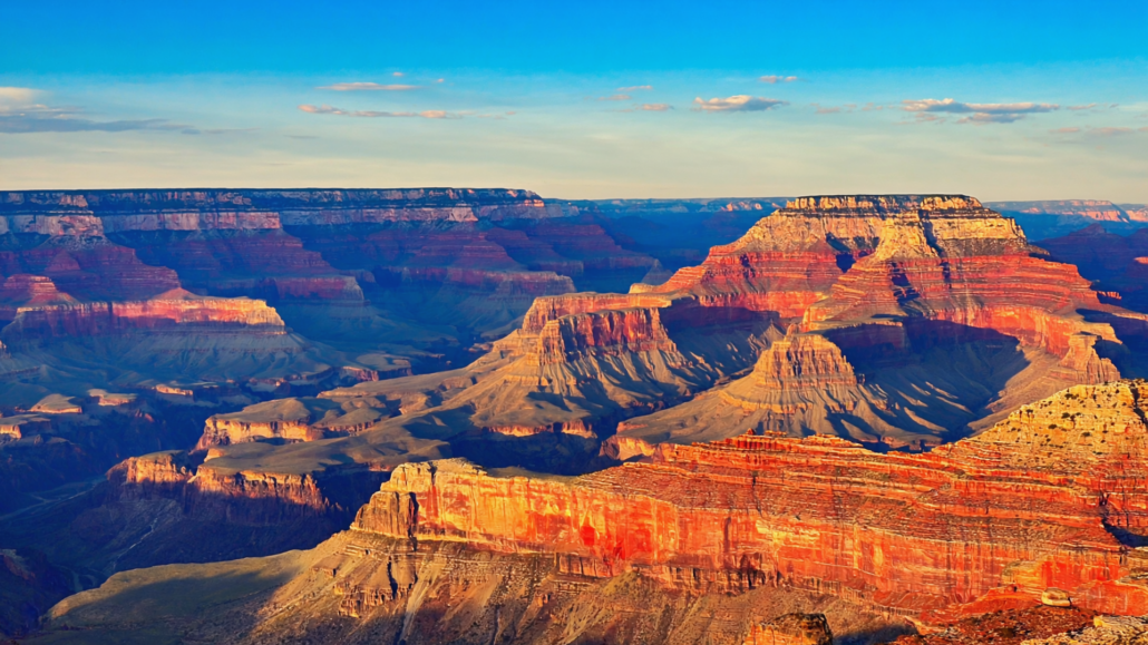
The wall in front of you drops nearly a mile straight down. Layered bands of red, cream, purple, and gray stack on top of each other like the pages of a book left open for two billion years. Each stripe is a chapter. Each color shift marks a catastrophe, a sea, a desert, a volcanic eruption, or an ice age that reshaped an entire continent. The Grand Canyon doesn’t just sit there looking dramatic. It is, in the most literal sense, a record of Earth’s entire geological life, exposed by one persistent river and the slow violence of time.
Most visitors arrive at the rim and feel something overwhelming without quite knowing why. The scale is part of it. But the real power of the canyon comes from understanding what you’re actually looking at: nearly two billion years of planetary history, compressed into a single viewpoint. This guide unpacks that history in plain language, from the oldest basement rocks at the bottom to the limestone cap at the top, and explains exactly how plate tectonics, volcanic activity, and the relentless cutting of the Colorado River combined to build one of Earth’s most complex geological features. By the time you reach the South Rim, you’ll see something entirely different from what a first-time visitor sees.
Why Grand Canyon Geology History Matters Before You Arrive
Understanding the basic framework of Grand Canyon geology history transforms a sightseeing trip into something genuinely educational and emotionally resonant. Without that framework, visitors tend to spend their time at overlooks photographing the view and then moving on. With it, they start asking questions, following layers across miles of canyon wall, and connecting what they see to events that happened before multicellular life even existed on Earth.
The Grand Canyon exposes rock sequences that geologists call a “layer cake” stratigraphy, a term used because the formations sit in broadly horizontal bands that can be traced across enormous distances. What makes the canyon unusual is the sheer range of those layers. Most rock outcrops around the world expose a few hundred million years of history at best. The Grand Canyon walls record nearly two billion years, with a famous gap in the middle called the Great Unconformity, where roughly 1.2 billion years of rock simply don’t exist. That gap alone is one of the most studied geological puzzles in North America.
The geological story also intertwines with the cultural history of the region. Indigenous peoples, including the Havasupai, Hualapai, Navajo, Hopi, and Ancestral Puebloans, have lived in and around the canyon for thousands of years. Their relationship with the landscape was shaped by its geology: the springs that emerge where permeable and impermeable rock layers meet, the sheltered alcoves carved by differential erosion, the red soils that supported agriculture along certain terraces. Grand Canyon cultural history and its geological story are not separate threads. They are woven together from the very beginning.
Before diving into the rock record itself, it’s worth orienting to scale. The canyon is approximately 277 miles long, up to 18 miles wide, and over a mile deep at its deepest point near Toroweap. The South Rim sits at roughly 7,000 feet above sea level. The Colorado River at the bottom runs at approximately 2,500 feet elevation. Every layer you see between those two points represents a distinct episode in Earth’s history, and each one has a name, an age, and a story.
The Oldest Rocks: Vishnu Basement and the Birth of a Continent
At the very bottom of the Grand Canyon, where the Colorado River cuts through dark, swirling rock that looks almost metallic in low light, you are standing at the beginning of the story. The Vishnu Basement Rocks are the oldest exposed formations in the canyon, dating to roughly 1.7 to 1.8 billion years ago. They formed during a period when North America itself was being assembled, a process called the Trans-Hudson Orogeny, during which ancient island arcs and ocean floor fragments were sutured together through the collision of tectonic plates.
The Vishnu Schist, the most recognizable component of this basement complex, started life as sedimentary and volcanic rock deposited on an ancient ocean floor. When plate collision drove those rocks deep into the crust, intense heat and pressure transformed them into metamorphic rock, a process called metamorphism. The result is the dark, banded, crystalline schist you can see threading through the inner gorge today. Cutting through the schist in brilliant pink ribbons is the Zoroaster Granite, formed when magma intruded into the schist and cooled slowly underground around 1.65 to 1.7 billion years ago.
These rocks are so old that they predate almost all complex life on Earth. When the Vishnu Schist was forming, the most complex organisms on the planet were microbial mats floating in shallow seas. The continents were in completely different positions. Oxygen levels in the atmosphere were still rising toward levels that would eventually support animal life. Looking at these rocks from a river raft at the bottom of the canyon, or from the Bright Angel Trail where it cuts through the inner gorge, is as close as most people will ever get to touching the Precambrian Earth.
What the Inner Gorge Tells Us About Plate Tectonics
The formation of the Vishnu Basement Rocks is a direct product of plate tectonic processes. The collision that created them was similar in scale to the ongoing collision between India and Asia that is building the Himalayas today. When those ancient plates collided, ocean crust was subducted downward, volcanic arcs formed above the subduction zone, and eventually the arc itself was accreted onto the growing proto-North American continent. The heat generated by this collision is what metamorphosed the original sediments into schist.
This is also why the inner gorge looks so different from the rest of the canyon. While the upper walls are composed of sedimentary rock laid down in horizontal layers, the basement rocks are tilted, folded, and sheared by ancient tectonic forces. They are the roots of a mountain range that once rivaled the Rockies in height, ground down to a flat plain over hundreds of millions of years before the next chapter of deposition began.
The Grand Canyon Supergroup: A Chapter That Almost Disappeared
Above the Vishnu Basement, and visible from certain vantage points along the South Rim and more clearly from the North Rim, are a set of tilted rock layers known collectively as the Grand Canyon Supergroup. These sedimentary and volcanic rocks were deposited between roughly 1.25 billion and 740 million years ago, during a period when the canyon region sat near the equator and was repeatedly flooded by shallow seas and lake environments.
The Supergroup formations are remarkable for several reasons. First, they contain some of the earliest evidence of complex microbial life in North America, in the form of stromatolites, layered structures built by photosynthesizing cyanobacteria. Second, they record multiple episodes of rifting, when the crust stretched and cracked as an ancient supercontinent began to break apart. Third, and most dramatically, they were almost entirely removed from the Grand Canyon region before the overlying Paleozoic sedimentary layers were deposited.
The process that removed them was the Great Unconformity, one of the most famous geological features in North America. The USGS Grand Canyon geology page describes the Great Unconformity as a contact surface where Cambrian-aged sedimentary rocks sit directly on top of the Precambrian basement, representing a gap of roughly 1.2 billion years of missing time. In some parts of the canyon, you can place your hand on the contact between 525-million-year-old Tapeats Sandstone and 1.7-billion-year-old Vishnu Schist, with nothing in between. That missing interval represents erosion, non-deposition, and possibly a global glaciation event known as Snowball Earth, during which glaciers may have extended to the equator.
Where the Grand Canyon Supergroup is preserved, visible in the tilted wedges of dark red and brown rock called the Unkar and Chuar Groups in the eastern canyon, it appears at an angle to the overlying horizontal layers. This angular relationship confirms that the Supergroup was deposited, tilted by tectonic forces, and then eroded before the Paleozoic seas moved in. The canyon is not just showing you rock. It is showing you an entire mountain-building cycle, from deposition to erosion, compressed into a single cross-section.
The Paleozoic Layer Cake: Seas, Deserts, and Swamps Over 300 Million Years
The most visually dramatic section of the Grand Canyon walls, the broad horizontal bands of tan, red, gray, and cream that define the canyon’s iconic silhouette, represents the Paleozoic Era, spanning roughly 525 to 270 million years ago. During this time, the region that is now northern Arizona experienced an extraordinary variety of environments: deep tropical seas, tidal flats, coastal dunes, inland lakes, and equatorial rainforests. Each environment left behind a distinctive rock type, and those rock types are now stacked in sequence for anyone at a rim viewpoint to read.
Tapeats Sandstone, Bright Angel Shale, and Muav Limestone: The Cambrian Trio
The three lowest Paleozoic formations, collectively called the Tonto Group, were deposited during the Cambrian Period, roughly 505 to 525 million years ago. The Tapeats Sandstone is a brown, cross-bedded sandstone representing ancient beach and nearshore environments as a Cambrian sea transgressed across the eroded Precambrian surface. Above it, the Bright Angel Shale represents deeper, quieter water environments, a green-gray mudstone that forms the broad, flat platform called the Tonto Platform, visible as a wide bench about a third of the way down the canyon walls. Above that, the Muav Limestone records even deeper marine conditions as the sea continued to rise.
These three formations record a single event: the flooding of North America by a warm, shallow sea from the west. The progression from beach sand to muddy seafloor to limestone is called a transgressive sequence, and it is one of the clearest examples of sea-level rise recorded in the geological record anywhere in the world. Fossils found in these layers include trilobites, brachiopods, and early mollusks, the first wave of complex animal life during the Cambrian Explosion.
Temple Butte, Redwall, and Surprise Canyon: The Devonian and Mississippian Record
Above the Cambrian trio, a gap in the record represents the Ordovician and Silurian periods, when either no rock was deposited in the region or whatever formed was subsequently eroded. The story picks up again with the Temple Butte Formation, a Devonian-age limestone visible primarily in the eastern canyon as pale, lens-shaped bodies filling ancient stream channels cut into the Muav. Fish fossils appear here, marking the Devonian as the age of fishes in the evolutionary record.
The most visually striking single formation in the entire canyon may be the Redwall Limestone, a sheer, 500-foot cliff of gray limestone that forms a nearly impassable barrier in the middle of the canyon walls. Despite its name, the Redwall is not actually red; it is gray limestone that has been stained red by iron oxide washing down from the overlying Supai Group above. The Redwall was deposited during the Mississippian Period, roughly 330 to 340 million years ago, in a clear, warm, shallow tropical sea teeming with crinoids, brachiopods, corals, and sharks. At that time, the canyon region was near the equator, not far from where the Bahamas are today.
Tucked between the Redwall and the overlying Supai Group is the Surprise Canyon Formation, a relatively recent discovery in geological terms. Found only in isolated pockets where it filled ancient channels cut into the Redwall, it records a brief marine incursion during the Mississippian and contains some of the canyon’s most unusual fossils, including large marine sharks.
Supai Group, Hermit Shale, and Coconino Sandstone: The Pennsylvanian and Permian World
The upper third of the canyon’s Paleozoic sequence records a dramatic environmental shift. As the ancient continent of Pangaea assembled and the region moved away from the equator, the environment transitioned from tropical seas to river floodplains, coastal mudflats, and eventually one of the largest desert dune fields in Earth’s history.
The Supai Group, a sequence of red sandstones and mudstones deposited roughly 285 to 315 million years ago, represents alternating river, floodplain, and shallow marine environments. The red color comes from iron oxide, indicating oxidizing conditions, consistent with a semi-arid, terrestrial environment. The Supai contains tracks of early reptiles and amphibians, marking the colonization of land environments well underway by this point.
Above the Supai, the Hermit Shale is a soft, red mudstone deposited in river floodplains, easily recognized because it weathers into gentle slopes rather than the sheer cliffs formed by harder formations. The Hermit contains abundant plant fossils, including ferns and conifers, and is often described as recording an ancient coastal plain environment.
The Coconino Sandstone is one of the most dramatic formations in the canyon, a brilliant white or cream-colored cliff of pure quartz sandstone up to 350 feet thick. It was deposited roughly 275 million years ago as a massive erg, the geological term for a large sea of sand dunes. The large-scale cross-bedding visible in the Coconino represents the preserved faces of ancient dunes, migrating under wind across a vast arid landscape. Trackways of ancient reptiles and amphibians are preserved on some of those ancient dune surfaces. At the time of its deposition, the Grand Canyon region was positioned at roughly 5 to 10 degrees north latitude, in a configuration similar to the modern Sahara.
Toroweap Formation and Kaibab Limestone: The Final Permian Seas
The canyon’s Paleozoic record ends with two limestone formations: the Toroweap Formation and the Kaibab Limestone. Both record the return of marine conditions as a shallow sea flooded the region one final time during the Permian Period. The Kaibab Limestone forms the very surface of the South Rim, the rock you stand on when you walk to the edge. It is roughly 270 million years old, rich in marine fossils including sponges, brachiopods, corals, and shark teeth.
After the Kaibab was deposited, the Permian-Triassic extinction event, the largest mass extinction in Earth’s history, reshaped life across the planet. The rocks recording that event and everything that followed are largely absent from the canyon itself, eroded away by the time the Colorado River began cutting downward. The story jumps from the Permian to the very recent past in geological terms.
How the Colorado River Carved the Canyon: The Erosion Story
Plate tectonics built the rock sequence. The Colorado River exposed it. Understanding how erosion built the Grand Canyon is as important as understanding how the rocks were deposited, and the mechanics are more complex than most people realize.
The Colorado River did not simply carve downward from the beginning. The current scientific understanding, supported by multiple lines of evidence including helium dating of cave minerals, suggests that the canyon achieved most of its current depth relatively recently in geological terms, within the last 5 to 6 million years. Before that, the river or its precursors may have drained in a different direction entirely, and the landscape looked dramatically different.
What triggered the rapid incision was a combination of factors. The Basin and Range extension, a period of crustal stretching across the American Southwest, lowered base levels (the elevation toward which rivers erode) dramatically. The integration of the Colorado River to its current outlet at the Gulf of California, which occurred roughly 5 to 6 million years ago according to USGS research on Colorado River integration, gave the river a steep gradient and enormous erosive energy. With a steep gradient, fast-moving water carries tremendous sediment load and cuts downward rapidly.
The canyon widened through a different process than it deepened. While the Colorado River cuts vertically through the rock using the abrasive action of sand and gravel it carries, the canyon walls erode laterally through a combination of weathering, rockfall, and the cutting of side canyons by tributary streams. Softer rock layers like the Hermit Shale and Bright Angel Shale weather back faster than harder formations like the Redwall Limestone and Coconino Sandstone, creating the stair-step profile of cliffs and slopes visible from every South Rim viewpoint.
The Role of Tributaries and Side Canyons
The Grand Canyon is not a single slot cut by a single river. It is an immensely complex network of side canyons, tributary gorges, and isolated buttes and mesas carved by thousands of smaller streams draining into the Colorado. The dramatic buttes and temples visible from the South Rim, named formations like Brahma Temple, Zoroaster Temple, and Vishnu Temple, are not random rock formations. They are remnants of the canyon walls, isolated by erosion as side canyons cut headward from both the north and south.
The North Rim receives significantly more precipitation than the South Rim, partly because it sits higher (averaging around 8,200 feet compared to 7,000 feet for the South Rim). This means more snowmelt and runoff on the north side, which drives faster erosion of north-side tributaries. The result is that the canyon is not symmetrical: the North Rim is set back nearly twice as far from the river as the South Rim, a directly observable consequence of differential erosion driven by climate and elevation.
Grand Canyon Geology Explained: Reading the Layers From Any Viewpoint
One of the great pleasures of the South Rim is that Grand Canyon geology explained visually at almost any overlook. You don’t need to hike into the canyon to read the rock record. From Mather Point, Yavapai Point, or Desert View, the full stratigraphic sequence is visible as a series of horizontal bands descending to the river.
A simple way to orient yourself: start at the top with the pale gray Kaibab Limestone forming the rim surface, then drop your eye to the next distinctive cliff band, the cream-and-white Coconino Sandstone. Below that, the reddish slopes of the Hermit Shale and the banded red-and-tan cliffs of the Supai Group descend to the most dramatic single feature in the canyon wall, the sheer gray cliff of the Redwall Limestone, stained red. Below the Redwall, the canyon opens into the broad Tonto Platform of the Bright Angel Shale, and then drops into the dark inner gorge of the Vishnu Basement Rocks.
| Formation | Approximate Age | Rock Type | Environment of Deposition | Visual Clue at the Rim |
|---|---|---|---|---|
| Kaibab Limestone | 270 million years | Marine limestone | Warm shallow sea | ✅ The rim surface you walk on |
| Toroweap Formation | 273 million years | Limestone/sandstone | Coastal/marine | ⚠️ Below Kaibab; subtle cliff |
| Coconino Sandstone | 275 million years | Aeolian sandstone | Vast desert dune field | ✅ Bright white/cream cliff band |
| Hermit Shale | 280 million years | Red mudstone | River floodplain | ✅ Soft red slope below Coconino |
| Supai Group | 285–315 million years | Red sandstone/mudstone | Rivers and coastal flats | ✅ Banded red cliffs and slopes |
| Redwall Limestone | 335 million years | Marine limestone | Clear tropical sea | ✅ Massive red-stained gray cliff |
| Bright Angel Shale | 505 million years | Green-gray mudstone | Shallow seafloor | ✅ Wide flat Tonto Platform |
| Tapeats Sandstone | 525 million years | Brown sandstone | Ancient beach | ⚠️ Base of Tonto Platform |
| Vishnu Schist / Zoroaster Granite | 1.65–1.8 billion years | Metamorphic/igneous | Deep crustal collision zone | ✅ Dark inner gorge at river level |
Grand Canyon Scenic Viewpoints for Geology Enthusiasts
Not all rim viewpoints offer the same geological perspective. Grand Canyon scenic viewpoints vary significantly in what they reveal about the rock record, and choosing the right overlook for geology viewing makes an enormous difference in what you actually learn.
Yavapai Point and Geology Museum
Yavapai Point is widely considered the best single viewpoint for understanding the canyon’s geological structure. The National Park Service operates the Yavapai Geology Museum at this location, where large windows frame the canyon and interpretive displays directly connect what you see to the rock formations in front of you. The panorama from Yavapai is broad enough to show the full sequence from rim to river, and the orientation of the canyon at this point allows you to see both the Tonto Platform and the inner gorge clearly. If your primary interest is understanding the geology, start here.
Desert View Watchtower Area
At the eastern end of Desert View Drive, the canyon takes on a different character. The Grand Canyon Supergroup, those tilted Precambrian sedimentary layers largely absent from the western canyon, is visible here in the eastern canyon walls as wedge-shaped formations angled against the horizontal Paleozoic layers above. This is one of the few places from the rim where you can see the angular unconformity between the Supergroup and the overlying Tapeats Sandstone, which represents hundreds of millions of years of missing time. The view from the Desert View area is also broader and more panoramic than the central rim viewpoints, extending far into the Marble Canyon corridor to the east.
Mather Point
The most visited viewpoint in the park, Mather Point offers an excellent overview of the canyon’s middle section. The Redwall Limestone cliff is particularly dramatic from this vantage, and the Tonto Platform is clearly visible as a broad bench below the Redwall. On a clear day, the dark inner gorge is visible at river level, and the full color transition from the cream Coconino through the red Supai and Hermit to the gray Redwall is laid out in a single view. Mather Point is often crowded, but early morning visits, especially at sunrise, offer the best combination of soft light and manageable crowds.
Bright Angel Trail: Geology on Foot
No rim viewpoint matches the experience of hiking down into the canyon and touching the rock formations directly. The Bright Angel Trail descends through almost the entire Paleozoic sequence within the first three miles from the trailhead, passing through the Kaibab, Toroweap, Coconino, Hermit, Supai, Redwall, Muav, Bright Angel Shale, and Tapeats formations before reaching the Tonto Platform. The contact between the Tapeats Sandstone and the underlying Vishnu Schist, the Great Unconformity itself, is visible along the trail near the 1.5-mile Rest House. Touching that contact, placing one hand on rock that is 525 million years old and the other on rock that is 1.7 billion years old, is one of the most viscerally powerful geological experiences available anywhere in the United States.
Grand Canyon Cultural History: Human Life in a Geological Landscape
The geological story of the Grand Canyon and its human story cannot be separated cleanly. The same forces that created the rock record also shaped the conditions that made human habitation possible, and in some cases, extraordinarily challenging.
Archaeological evidence confirms human presence in and around the Grand Canyon for at least 12,000 years, with split-twig figurines found in caves along the canyon walls dating to roughly 4,000 years ago. These figurines, fashioned from single willow or cottonwood twigs twisted into the shape of deer or bighorn sheep, represent some of the earliest ritual objects found in the American Southwest. Their presence deep within the canyon’s cave systems suggests that ancient peoples were not merely passing through but engaging with the landscape in complex ways.
The Ancestral Puebloans, often called the Anasazi in older literature, built granaries and dwellings on canyon ledges, taking advantage of the same differential erosion that created sheltered alcoves in the softer rock layers. The Bright Angel Pueblo site near the current trailhead dates to roughly 1050 to 1150 CE. The Cohonina people occupied the South Rim, and the Havasupai have maintained continuous presence in the western canyon, centered on Havasu Canyon, for centuries. The Hopi trace their ancestry directly to the Ancestral Puebloans and consider the canyon a place of spiritual origin.
The springs and seeps that made year-round habitation possible emerge at specific geological contacts, most notably where the permeable Muav Limestone meets the relatively impermeable Bright Angel Shale. The Bright Angel Spring, which supports the only developed water source on the Bright Angel Trail, emerges at this contact. Ancient peoples understood this relationship intuitively, and many of the most densely occupied archaeological sites cluster around these geological spring zones.
European-American exploration of the canyon began in earnest with John Wesley Powell’s 1869 river expedition, the first documented descent of the Colorado River through the Grand Canyon. Powell, a geologist himself, published detailed observations of the rock formations and was among the first to describe the Great Unconformity in scientific terms. His reports transformed the canyon from a geographic obstacle into a scientific destination, and his names for many formations, including the Vishnu and Zoroaster, reflect the mythological naming convention he applied across the region.
Planning Your Visit: Turning Geological Knowledge Into a Better Trip
Knowing what you’re looking at changes the experience of visiting the Grand Canyon. But knowing where to start before you even enter the park makes the trip more efficient, more educational, and more memorable.
A natural first stop for visitors approaching the South Rim along Highway 64 is the Grand Canyon Visitor Center IMAX, located in Tusayan just outside the South Rim entrance gates. This privately operated facility, distinct from the NPS-operated visitor center inside the park at Grand Canyon Village, serves as an orientation hub where you can get context for everything you’re about to see before you arrive at the rim.
The flagship film at the Grand Canyon IMAX Theater, “Grand Canyon: Rivers of Time,” presents the geological and cultural history of the canyon on a six-story screen using IMAX with Laser technology. Watching the canyon’s formation unfold at that scale, before you stand at the rim, builds the mental framework that makes every viewpoint more meaningful. The film covers the same geological story described in this article, from the ancient basement rocks through the cutting of the river, in a format that makes the timescales viscerally comprehensible. Book IMAX tickets online and save 20% compared to at-the-door pricing.
The Grand Canyon Visitor Center IMAX also sells various National Park entrance passes on-site, a practical time-saver during peak season when entrance gate queues can be significant. For visitors who want to explore the canyon’s geological features up close with expert guidance, Pink Jeep Tours, recognized as Best Tour Operator, operates directly from the facility’s front door. Every Pink Jeep Tour originating from the Grand Canyon Visitor Center IMAX includes a ticket to “Grand Canyon: Rivers of Time,” combining the geological orientation film with hands-on exploration of the canyon’s formations. The combination is particularly effective for first-time visitors who want to connect what they’ve learned on screen to what they see in the field.
For road-trip travelers and EV drivers, the facility offers Ultra-Fast 150 kW and Hyper-Fast 350 kW EV charging on-site, making it a practical logistical stop as well as an educational one. On-site dining at Pizza Hut Express and Explorers Café, along with a large souvenir and hiking gear retail store, means you can handle most pre-park logistics without backtracking.
From a geological tourism perspective, the sequence that works best is: watch the IMAX film for context, stop at Yavapai Point and the Geology Museum for an overview, walk the first mile of the Bright Angel Trail to see the formations up close, and then explore Desert View Drive to see the eastern canyon’s Supergroup formations. That sequence takes you from a cinematic overview to a hands-on encounter with the rock record in a logical progression that builds understanding at each step. If you’re traveling with kids, the shuttle system along the Grand Canyon Tusayan shuttle corridor makes moving between viewpoints straightforward without the challenge of parking at multiple overlooks.
The Grand Canyon Travel Guide Framework: Geology-First Trip Planning
A Grand Canyon travel guide built around geological understanding gives visitors something most itineraries miss: a coherent narrative thread that connects everything they see. Instead of a checklist of viewpoints, geology-first planning creates a progression from oldest to youngest rock, or from big-picture overview to close-up detail, that makes the canyon legible rather than simply overwhelming.
Day One: Orientation and Overview
Before entering the park, stop at the Grand Canyon Visitor Center IMAX in Tusayan to watch “Grand Canyon: Rivers of Time” and pick up your park entrance pass. This positions the geological story as the lens through which you’ll interpret everything else. On entering the park, head directly to Yavapai Point and spend at least 45 minutes at the Geology Museum using the interpretive displays to identify the major formations visible from the window. Walk the Rim Trail east toward Mather Point for additional perspectives, paying attention to how the canyon’s profile changes as you move.
Day Two: Down Into the Record
An early morning start on the Bright Angel Trail gives you the best light for photography and the coolest temperatures for hiking. Descend at least to the 1.5-mile Rest House, where the Great Unconformity is visible. If you are experienced and well-supplied, continuing to the 3-mile Rest House takes you through the Redwall and into the Cambrian formations. Return before midday heat builds. An afternoon drive to Desert View, stopping at Grandview Point and Lipan Point along the way, reveals the eastern canyon’s Supergroup formations and provides a completely different visual perspective on the same geological story.
Day Three: Guided Exploration
A Pink Jeep Tour from the Grand Canyon Visitor Center IMAX adds expert interpretation to the geological features you’ve already identified independently. Guides familiar with the canyon’s rock record can point out features not visible from standard overlooks and provide context for what you’ve already seen. This is particularly valuable for visitors who want to understand the canyon’s cultural history alongside its geology, as guides typically weave Indigenous history and Powell-era exploration into the geological narrative.
Photography enthusiasts will find that different formations respond to light in dramatically different ways. The Redwall Limestone, stained with iron oxide, glows in warm morning light. The Coconino Sandstone turns almost luminous at sunset. The dark Vishnu Schist at river level absorbs light rather than reflecting it, creating deep shadow contrasts that make for compelling long-exposure photography. The Grand Canyon wildlife and viewing tips resource is also worth reviewing before your visit, as geological features like the Tonto Platform and Bright Angel Shale slopes create specific wildlife habitat zones where condors, mule deer, and canyon wrens are commonly observed.
Frequently Asked Questions About Grand Canyon Geology and History
How old is the Grand Canyon itself?
The rocks exposed in the canyon range from roughly 270 million years old at the rim to approximately 1.8 billion years old at the bottom of the inner gorge. The canyon as a physical feature, the gorge carved by the Colorado River, is much younger. Current geological understanding suggests the canyon achieved most of its current depth within the last 5 to 6 million years, though some portions of the canyon may have begun forming earlier. The distinction between the age of the rocks and the age of the canyon itself is important: the rocks are ancient, the canyon is geologically recent.
What is the Great Unconformity and why is it significant?
The Great Unconformity is a contact surface in the Grand Canyon where Cambrian-aged sedimentary rocks (approximately 525 million years old) sit directly on top of Precambrian basement rocks (approximately 1.7 billion years old), with roughly 1.2 billion years of missing rock record in between. It is significant because it represents either a massive erosion event, a long period of non-deposition, or both, and may be connected to a global glaciation event. It is one of the most studied and dramatic geological unconformities on Earth.
Why does the Grand Canyon have so many different colors?
The color variations in the canyon walls reflect differences in rock type and mineral composition. The red and orange colors in the Supai Group and Hermit Shale come from iron oxide (essentially rust) in the rock, indicating oxidizing conditions during deposition. The gray color of the Redwall Limestone is the rock’s natural color, stained red by iron washing down from the formations above. The white or cream color of the Coconino Sandstone reflects nearly pure quartz sand. The dark color of the Vishnu Schist comes from the dense, iron-and-magnesium-rich minerals formed under intense metamorphic heat and pressure.
Did volcanoes play a role in the Grand Canyon’s formation?
Yes, volcanic activity is part of the canyon’s geological story in multiple ways. The Zoroaster Granite in the inner gorge formed when magma intruded into the Vishnu Schist during the Precambrian. In the western canyon, relatively young lava flows (in geological terms, within the last million years) poured over the rim and into the canyon, temporarily damming the Colorado River. The remnants of these lava dams are visible in the western canyon. Additionally, the Grand Canyon Supergroup contains volcanic formations associated with ancient rifting events.
What is the Vishnu Schist and how was it formed?
The Vishnu Schist is a metamorphic rock that forms the floor of the inner gorge. It began as sedimentary and volcanic rock deposited on an ancient ocean floor roughly 1.8 billion years ago. When tectonic plate collision drove those rocks deep into the crust, intense heat and pressure transformed their mineral structure, creating the dark, foliated (layered) schist visible today. The process took tens of millions of years and occurred at depths of perhaps 12 to 15 miles below the surface.
How long did it take the Colorado River to carve the Grand Canyon?
This is an actively debated question in geology. The prevailing current view, based on thermochronology and helium dating of cave minerals, suggests that most of the canyon’s current depth was achieved within the last 5 to 6 million years. Some evidence suggests older canyon segments in the western canyon, possibly dating to 70 million years ago, though this remains contested. The integration of the Colorado River to its current drainage path, giving it the steep gradient needed for rapid incision, is generally dated to approximately 5 to 6 million years ago.
Can I see the geological layers from the rim without hiking into the canyon?
Absolutely. The major formations are visible from virtually every South Rim viewpoint. Yavapai Point, with its on-site Geology Museum operated by the NPS, provides the best interpretive experience for identifying formations from the rim. Mather Point, Desert View, and Lipan Point all offer clear views of the full stratigraphic sequence. A pair of binoculars significantly enhances the experience, allowing you to pick out individual formation contacts and examine features like cross-bedding in the Coconino Sandstone.
What is the best way to learn about Grand Canyon geology before visiting?
The combination of reading a basic overview (like this article), watching an interpretive film, and then visiting specific geological viewpoints in sequence is the most effective approach. The “Grand Canyon: Rivers of Time” film at the Grand Canyon IMAX Theater in Tusayan presents the geological story in a visually immersive format that makes the timescales accessible. The USGS Grand Canyon geology resources provide detailed technical information for readers who want to go deeper into the science before they arrive.
What fossils can be found in the Grand Canyon?
The Grand Canyon’s rock record contains fossils spanning much of the history of complex life. The Cambrian formations (Tapeats, Bright Angel, Muav) contain trilobites, brachiopods, and early mollusks. The Devonian Temple Butte Formation contains fish fossils. The Mississippian Redwall Limestone is rich in crinoids, brachiopods, corals, and sharks. The Pennsylvanian and Permian formations (Supai, Hermit, Coconino) contain amphibian and reptile trackways, as well as plant fossils. The Kaibab Limestone at the rim contains sponges, brachiopods, and shark teeth. Removing or disturbing fossils in the national park is prohibited.
How does Grand Canyon cultural history connect to its geology?
The canyon’s geological structure directly shaped where and how Indigenous peoples could live and travel within it. Springs emerge at specific rock contacts, most importantly where the Muav Limestone meets the Bright Angel Shale, and ancient habitation sites cluster around these geological water sources. The canyon’s varied rock layers also provided different raw materials for tool-making, construction, and pigments. The Havasupai, Hopi, Navajo, Hualapai, and other nations maintain deep cultural and spiritual connections to specific geological features and landscape elements that have been continuous for centuries.
What is the difference between the South Rim and North Rim geologically?
Both rims expose the same rock formations at the surface, primarily the Kaibab Limestone. The primary difference is elevation and erosion rate. The North Rim sits approximately 1,200 feet higher than the South Rim, receives significantly more precipitation, and drains toward the canyon rather than away from it. This means North Rim tributaries erode more aggressively, which is why the canyon is asymmetrical: the North Rim is set back nearly twice as far from the river as the South Rim. The higher elevation also means the North Rim is typically closed from late November through mid-May due to snow.
Is it true that Will Smith bungee jumped over the Grand Canyon?
Yes, as part of a charity initiative, Will Smith completed a bungee jump over the Grand Canyon. One lucky fan was selected to be present for the event, which drew significant attention to the canyon as a site of both natural wonder and human adventure. You can read more about the contest for Will Smith’s Grand Canyon bungee jump for the full story.
Key Takeaways for Understanding Grand Canyon Geology and Planning Your Visit
- The canyon exposes nearly two billion years of Earth’s geological history, from the 1.7-billion-year-old Vishnu Schist at the bottom to the 270-million-year-old Kaibab Limestone at the rim.
- The rock sequence was built by plate tectonics, including continental collision, rifting, and repeated marine flooding, and then exposed by the erosive cutting of the Colorado River over the last 5 to 6 million years.
- The Great Unconformity, where Cambrian rock sits directly on Precambrian basement with 1.2 billion years missing, is one of the most dramatic geological features in North America and is visible from the Bright Angel Trail.
- Different viewpoints reveal different geological features: Yavapai Point for the broadest geological overview, Desert View for the Supergroup formations, Bright Angel Trail for hands-on contact with the rock record.
- Grand Canyon cultural history is geologically grounded: Indigenous habitation patterns, water source locations, and spiritual landscapes all reflect the canyon’s rock structure.
- Watching “Grand Canyon: Rivers of Time” at the Grand Canyon IMAX Theater in Tusayan before entering the park provides the geological context that makes every viewpoint more meaningful. Book online and save 20%.
- Pink Jeep Tours departing from the Grand Canyon Visitor Center IMAX combine guided geological interpretation with the IMAX experience, and every tour includes a “Rivers of Time” ticket.
- The canyon’s colors are not arbitrary: each color reflects specific mineral content and depositional environment, and learning to read those colors turns any rim viewpoint into a geological classroom.
- For first-time visitors, the most effective sequence is: IMAX film for context, Yavapai Point for overview, Bright Angel Trail for up-close geology, Desert View Drive for the eastern canyon’s unique formations.

About the author
Explore The Canyon Editorial Team
See The Canyon
Learn more →


Leave a Reply
Want to join the discussion?Feel free to contribute!