
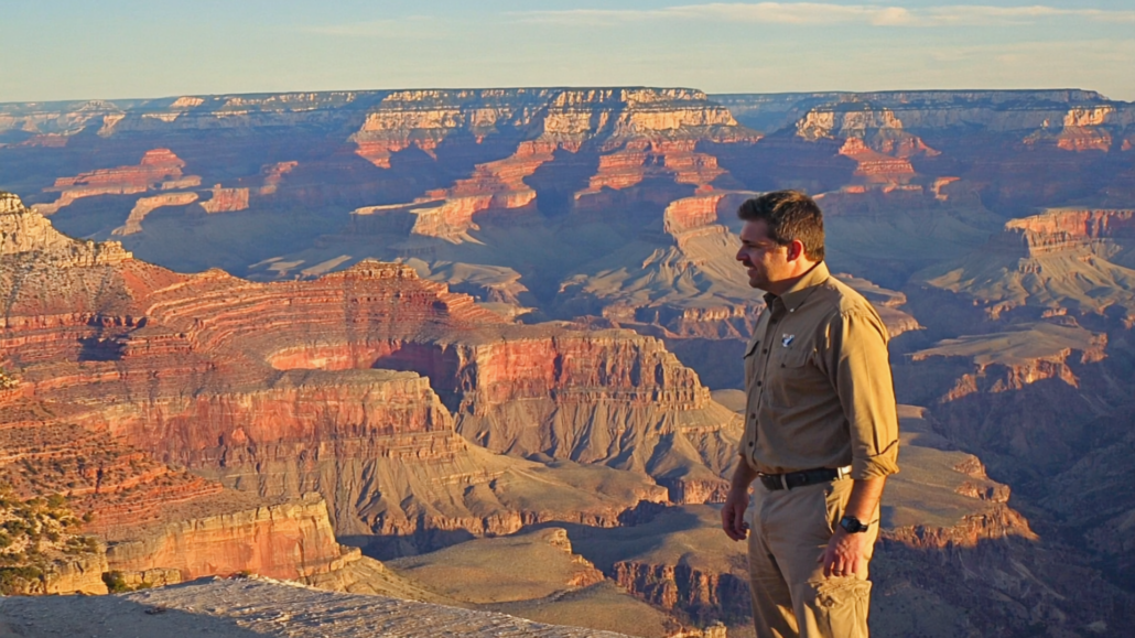
How the Grand Canyon’s Rock Layers Work: A Geologist’s Explainer for Curious Visitors
Most visitors standing at the South Rim of the Grand Canyon feel the same thing first: scale. The canyon is so vast, so deep, and so visually overwhelming that the rock itself almost becomes backdrop. But geologists will tell you that what you’re actually looking at is something far more extraordinary than scenery. You are looking at nearly two billion years of Earth’s history, stacked in plain sight, readable like a book if you know what the chapters mean.
This guide is for the curious visitor who wants to look at those walls and actually understand them. Not just to know that the canyon is “really old,” but to grasp why the layers exist, what they record, and why the story they tell is genuinely one of the most remarkable on the planet. Understanding Grand Canyon geology history transforms the experience from awe to comprehension, and comprehension tends to create a far more lasting memory than beauty alone.
Why the Grand Canyon’s Rock Record Is Unlike Anything Else on Earth
The Grand Canyon preserves a nearly unbroken record of geological time spanning close to two billion years, exposed in a single vertical cross-section that visitors can observe from the rim without specialized equipment. That is the core reason geologists treat it as one of the most important geological sites on the planet.
For context, consider what that span of time actually represents. Earth itself is roughly 4.5 billion years old. The oldest rocks visible at the very bottom of the canyon, in what geologists call the Vishnu Basement Rocks, formed approximately 1.7 to 1.8 billion years ago. The youngest rocks at the rim are around 270 million years old. The Colorado River and erosive forces carved through all of that in what geologists consider a geologically short period, somewhere between 5 and 6 million years, though recent research has complicated even that figure.
What makes the Grand Canyon’s exposure so scientifically valuable is not just the age of the rocks, but the relative clarity of the layering. In most parts of the world, rock sequences this old have been folded, faulted, metamorphosed, or simply buried beyond easy study. Here, the combination of an arid climate (which minimizes soil cover and vegetation), a plateau setting (which preserved the layers from mountain-building deformation), and a river system powerful enough to carve through all of it has produced something geologists rarely get: a clean vertical window into deep time.
For the visitor standing at the South Rim, this means that looking down into the canyon is, in a very literal sense, looking back in time. Every foot of depth is millions of years of additional history. The canyon is roughly a mile deep. The math, while imprecise, is staggering enough to reframe everything you see.
This is also why Grand Canyon South Rim tours that include geological orientation are consistently rated among the most memorable. Knowing what you’re looking at turns color bands and cliff faces into a timeline. The canyon stops being abstract and starts being specific.
Reading the Layers: How Stratigraphy Works and Why It Matters
Stratigraphy is the branch of geology concerned with the order, position, and age of rock layers, and the Grand Canyon is essentially its most famous classroom. The foundational principle is straightforward: in undisturbed sequences, older rocks are at the bottom and younger rocks are at the top. The Grand Canyon’s layers are, for the most part, undisturbed enough that this principle holds beautifully.
Each distinct band of color and texture you see from the rim corresponds to a different geological formation, each one representing a different environment and a different era. Geologists name these formations, and the names are worth learning because they appear on every interpretive sign, trail map, and guided tour at the canyon.
The Major Rock Groups from Rim to River
Starting at the top, at the rim level, and working downward through time, the sequence breaks into three major groups that geologists recognize as distinct packages of rock.
The Paleozoic Sedimentary Layers (270 to 525 million years old) form the bulk of what most visitors see when they look at the canyon walls from the rim. These are the horizontally banded cliffs and slopes that create the canyon’s iconic striped appearance. From top to bottom, the major formations in this group include:
- Kaibab Formation: The very top layer, forming the rim itself. This is the light-colored, almost white limestone that visitors walk on. It formed in a warm, shallow sea roughly 270 million years ago and is rich in marine fossils including brachiopods, corals, and sponges.
- Toroweap Formation: Sitting just below the Kaibab, this thinner layer of limestone, sandstone, and gypsum represents a similar shallow marine environment, slightly older than the Kaibab.
- Coconino Sandstone: One of the most visually striking formations, this pale, cream-colored band of cross-bedded sandstone was once a vast desert of wind-blown dunes, similar in scale to the modern Sahara. The preserved dune cross-bedding (diagonal layering within the formation) is visible from certain viewpoints and is one of the canyon’s most remarkable geological features. The Coconino is roughly 275 million years old.
- Hermit Formation: A reddish shale layer that slopes rather than cliffs, representing a coastal mudflat environment. It preserves fossil tracks of early reptiles and amphibians.
- Supai Group: A thick sequence of red sandstones and shales representing river floodplains and tidal flats. The Supai is responsible for much of the canyon’s deep red coloration in its middle sections.
- Redwall Limestone: One of the most prominent features of the canyon wall, this massive cliff-forming limestone appears red due to iron oxide staining from the layers above. The rock itself is actually gray. It formed in a warm, clear tropical sea and is roughly 340 million years old. The Redwall creates one of the canyon’s most formidable natural barriers, a nearly vertical cliff face hundreds of feet tall.
- Temple Butte Formation: A thinner layer of dolomite and limestone, more prominent on the west side of the canyon, representing a mix of marine and freshwater environments.
- Muav Limestone, Bright Angel Shale, and Tapeats Sandstone: These three formations together are often called the Tonto Group. They record a marine transgression, a rising sea that slowly flooded a desert landscape from west to east roughly 500 to 525 million years ago. The Tapeats Sandstone at the base represents a beach environment. The Bright Angel Shale above it represents deeper offshore mud. The Muav Limestone at the top represents even deeper, clearer water as the sea continued to rise. Together they tell one complete story of ocean advance.
The Great Unconformity sits between the Tapeats Sandstone and the rocks below it, and it is one of the most scientifically significant features in all of geology. An unconformity is a gap in the rock record, a surface where deposition stopped, erosion occurred, and time passed without leaving a clear sedimentary record. The Great Unconformity at the Grand Canyon represents a gap of roughly 250 million years, sometimes more, in which an entire mountain range rose, eroded completely flat, and left almost nothing behind. When the Cambrian sea advanced and deposited the Tapeats Sandstone on top of the eroded surface below, it was laying new rock directly on rocks that were already hundreds of millions of years older. The Great Unconformity is visible at multiple points in the canyon and has been described by geologists as a missing chapter of planetary history so large it staggers comprehension.
The Grand Canyon Supergroup (740 million to 1.2 billion years old)
Below the Great Unconformity, in the inner canyon where it is preserved, sits the Grand Canyon Supergroup. These tilted layers of sedimentary and volcanic rock are older than the Paleozoic sequence above and represent a completely different chapter. They are tilted rather than horizontal because they were deformed by ancient fault activity long before the overlying layers were deposited. The Supergroup is not visible from all rim viewpoints but can be observed from certain angles, particularly from Desert View on the East Rim.
The Vishnu Basement Rocks (1.7 to 1.8 billion years old)
At the very bottom of the canyon, along the Colorado River, the rocks change dramatically in character. The Vishnu Schist and related Zoroaster Granite are dark, crystalline, and visually unlike anything above them. These are metamorphic and igneous rocks formed deep within an ancient mountain range under conditions of extreme heat and pressure. The mountains they formed within have long since eroded away. What remains is their roots, exposed by the Colorado River cutting through everything above. Standing on the riverbank here, you are touching rock nearly as old as half the age of Earth itself.
What Creates the Colors? Understanding Grand Canyon’s Visual Palette
The Grand Canyon’s famous banded colors are not random, and they are not simply “pretty.” Each color reflects the mineralogy and depositional history of each formation, and once you understand the basic chemistry, you can start reading color as information.
Red and orange tones, dominant throughout the canyon’s middle sections, come primarily from iron oxide, specifically the mineral hematite. When iron-bearing minerals are exposed to oxygen in an ancient environment, they rust, just as modern iron rusts. Formations like the Hermit Shale and the Supai Group were deposited in environments where iron oxidation was active, producing the deep reds that define much of the canyon’s mid-section palette.
Tan and cream tones, particularly visible in the Coconino Sandstone and the Kaibab Formation at the rim, reflect quartz-rich compositions. The Coconino’s pale color comes from the fact that it was desert sand, mostly pure quartz grains with minimal iron content, cemented into rock over millions of years.
Gray tones in formations like the Redwall Limestone indicate marine carbonates, rocks composed largely of calcium carbonate from ancient marine organisms. The Redwall’s apparent red color is surface staining from iron-rich water seeping down from the Supai and Hermit layers above. Chip away the surface, and the rock is gray limestone.
Green and purple tones, visible in the Bright Angel Shale, indicate the presence of different iron compounds, specifically iron in a chemically reduced rather than oxidized state. This tells geologists that the Bright Angel muds were deposited in a low-oxygen marine environment where iron did not have the opportunity to fully oxidize.
The dark, almost black tones of the Vishnu Schist at the bottom represent entirely different chemistry: the minerals biotite and hornblende, which form under high-pressure metamorphic conditions. Their darkness is a direct expression of their formation environment, deep, hot, and under enormous pressure.
Understanding the colors adds a layer of reading to the rim experience that most visitors never access. The canyon is not just beautiful. It is legible.
Grand Canyon Cultural History: The Human Layers Above the Rock
The geological record is not the only history layered into the Grand Canyon. Human presence here stretches back at least 12,000 years, and the cultural history of the canyon is as richly stratified as the rock itself, though far less visible to the casual visitor.
The earliest evidence of human presence comes from split-twig figurines, small animal-shaped figures made from single willow or cottonwood twigs, found deep in canyon caves. These artifacts, dated to roughly 4,000 years ago, were likely created by hunter-gatherers as ceremonial offerings, possibly related to hunting rituals. The fact that they survive at all is a function of the canyon’s dry climate, the same arid conditions that keep the rock faces so clean and readable.
The Ancestral Puebloans, who occupied the canyon region from roughly 500 CE to 1200 CE, left behind granaries, dwellings, and pictographs throughout the canyon. The Tusayan Ruin, located near Desert View on the South Rim, is one of the best-preserved examples of their architecture in the park. These people farmed the canyon’s terraces, hunted its game, and understood its hydrology in ways that modern visitors rarely appreciate during a single-day visit.
Following the Ancestral Puebloans, the canyon became home to the Havasupai, Hualapai, Navajo, Paiute, and Zuni peoples, each with distinct relationships to the canyon’s resources and geography. The Havasupai, whose name translates roughly to “people of the blue-green water,” have lived continuously in the canyon for centuries and maintain a reservation within it to this day. Their relationship with the canyon predates any European contact by an enormous margin.
Spanish explorers reached the South Rim in 1540 when Hopi guides led García López de Cárdenas and his party to the canyon edge, making them the first Europeans to see it. They attempted to descend and failed, turned back by the canyon’s depth and terrain. It would be more than three centuries before John Wesley Powell’s famous 1869 river expedition would give the outside world its first comprehensive account of the canyon’s interior.
The late 19th century brought prospectors, tourism promoters, and eventually the Santa Fe Railway, which reached the South Rim in 1901 and transformed the canyon from a remote geological curiosity into a national destination. President Theodore Roosevelt visited in 1903 and made his famous declaration that the canyon should be kept unimpaired for future generations, a sentiment that eventually led to its designation as a National Monument in 1908 and a National Park in 1919.
Grand Canyon cultural history is not separate from the geology. The canyon’s depth, its water sources, its sheltered terraces, and its natural resources all shaped every human culture that has engaged with it. Understanding the rock helps explain why people settled where they did, why travel routes followed certain corridors, and why specific locations held spiritual significance. The geology and the human story are inseparable.
The Great Unconformity: A Gap in Time That Changed How We Think About Earth
No single feature of the Grand Canyon has generated more scientific discussion than the Great Unconformity, and for good reason. This contact surface, visible as a sharp line where ancient Precambrian rocks meet the much younger Cambrian Tapeats Sandstone, represents one of the largest identifiable gaps in Earth’s rock record anywhere on the planet.
The gap is not uniform. In some parts of the canyon, the unconformity represents approximately 250 million missing years. In others, where the tilted Grand Canyon Supergroup is preserved beneath the Tapeats, the gap is somewhat smaller. But even at its most compressed, the unconformity represents a span of time during which entire mountain ranges rose and eroded away, leaving only a planed-off surface that geologists call a peneplain.
John Wesley Powell, who named the canyon and conducted its first systematic geological survey, was among the first to recognize the significance of this contact. He understood that the horizontal Cambrian layers above could not simply rest on the rocks below without a massive span of missing time in between. The implications were profound for 19th-century geology: Earth had to be far older than most people, or most religious traditions, had assumed.
Recent research published in geological journals has complicated the picture further. Some geologists now propose that the Great Unconformity may record a global erosion event connected to a period known as “Snowball Earth,” when the planet was largely or entirely glaciated. The evidence is still being debated, but the hypothesis illustrates how a single rock contact visible from a hiking trail in Arizona can connect to questions about the entire planet’s history.
For visitors, the Great Unconformity is most easily observed at Plateau Point or along the Bright Angel Trail where the Tapeats Sandstone sits directly on the older rocks below. A ranger or a knowledgeable guide can point to the exact contact line. Once you know what you’re looking at, it is one of the most intellectually arresting things you can see in any national park.
How the Canyon Was Actually Carved: The Colorado River’s Role
The Colorado River did not simply “dig” the Grand Canyon in any straightforward sense. The story of how the canyon was carved is almost as complex as the story of the rocks it cut through, and it involves a combination of processes that geologists are still actively working to understand.
The basic mechanism is downcutting erosion. The Colorado River carries enormous quantities of sediment, including sand, gravel, and boulders, and this material acts as an abrasive tool, grinding away at the bedrock below. The river’s ability to cut downward depends on the gradient of the terrain, the hardness of the rock, and the volume and velocity of water moving through the system.
The Colorado Plateau, the high-elevation tableland through which the canyon is cut, began rising roughly 65 to 70 million years ago as part of broader tectonic activity across the American West. This regional uplift is crucial: it is what gave the river the gradient it needed to cut downward rapidly. A river on flat ground meanders and deposits sediment. A river on a steep gradient cuts down through whatever rock it encounters.
The age of the canyon itself has been a subject of active debate. For decades, the standard estimate placed the canyon’s formation at around 5 to 6 million years old, coinciding with the integration of the Colorado River into its current drainage system. More recent research has suggested that portions of the western canyon may be considerably older, perhaps 70 million years, representing an earlier, partially carved canyon that was later re-excavated. Other researchers dispute this interpretation. The debate is ongoing and unresolved, which is part of what makes Grand Canyon geology an active area of research rather than a settled textbook topic.
What is clear is that the canyon was not carved at a uniform rate. During periods of increased precipitation, particularly during the ice ages of the past 2 million years, the Colorado carried far more water and sediment than it does today, and canyon cutting accelerated dramatically. The canyon we see is partly the product of past climate conditions that no longer exist.
Side canyon erosion also played a major role. Tributary streams and washes, enlarged by flash floods, cut the canyon’s complex side canyons and alcoves, widening the overall system far beyond what the main river could accomplish alone. The canyon is roughly 10 miles wide at some points, a width that the river itself, barely 300 feet across, could never have produced through downcutting alone.
Where to Actually See the Geology: A Visitor’s Practical Guide
Understanding Grand Canyon geology history is one thing; knowing where to observe it is another. The South Rim offers several locations where the geological story becomes especially legible, and pairing those locations with a good orientation makes an enormous difference in what you actually take away from the visit.
Mather Point and Yavapai Geology Museum
Mather Point, the first major viewpoint most South Rim visitors reach, provides an excellent initial panorama. The Yavapai Geology Museum, located a short walk from Mather Point, is one of the best free geological orientation resources in any national park. Its large windows frame specific formations, and its interpretive panels walk visitors through the layer sequence in detail. For anyone serious about understanding the rock layers, this should be a first stop, not an afterthought. The National Park Service’s Grand Canyon geology overview provides supporting detail for what visitors see at Yavapai.
Desert View and the East Rim Drive
Desert View, at the eastern end of the South Rim, is where the Grand Canyon Supergroup becomes visible below the Great Unconformity. The tilted pre-Cambrian layers are observable from the Watchtower area, and the view eastward toward the Painted Desert adds a broader geological context. The East Rim Drive passes several viewpoints where different aspects of the layering become prominent at different angles and times of day.
The Bright Angel Trail
No rim viewpoint provides the same geological experience as walking down into the canyon itself. The Bright Angel Trail descends through the entire Paleozoic sequence, and interpretive signs along the trail identify each major formation. Even walking just to the first rest house (1.5 miles down, 1,120 feet of descent) takes you through the Kaibab, Toroweap, Coconino, and into the upper Hermit Formation. The rock underfoot changes character noticeably at each formation boundary. For trail tips and shuttle logistics, the Tusayan shuttle guide is a practical starting point for planning your approach to the trailhead.
Guided Jeep Tours
For visitors who want geological context delivered in real time rather than through self-guided reading, guided tours offer a significant advantage. Pink Jeep Tours, which operates out of Grand Canyon Visitor Center IMAX in Tusayan just outside the South Rim entrance, covers geological and cultural highlights with guides who can answer questions and point out features that most self-guided visitors miss entirely. Every Pink Jeep Tour originating from Grand Canyon Visitor Center IMAX includes a ticket to “Grand Canyon: Rivers of Time,” which itself provides an outstanding geological and cultural overview before you set foot on the rim. The combination of film orientation followed by guided ground exploration is genuinely one of the most efficient ways to develop a meaningful understanding of what you’re seeing.
The IMAX Advantage: Seeing the Canyon Before You Enter the Park
One of the most underused strategies for first-time Grand Canyon visitors is using a cinematic orientation before approaching the rim, not because the canyon needs introduction, but because context dramatically amplifies what the eye actually registers when you arrive.
Grand Canyon Visitor Center IMAX, located in Tusayan just minutes from the South Rim gates, screens “Grand Canyon: Rivers of Time” on a six-story screen using IMAX with Laser technology. The film covers the canyon’s geological formation, its cultural history, and its ecological significance in a format that no rim viewpoint can replicate. You see the canyon from angles that no visitor on foot ever will: aerial shots of the inner gorge, close-up footage of the Vishnu Schist at river level, time-lapse sequences that illustrate the layering in ways that static rock walls cannot convey.
The effect on the subsequent rim experience is measurable in practical terms. Visitors who arrive at the canyon with a mental model of the layer sequence, even a rough one, consistently report that the canyon feels more comprehensible and more emotionally resonant. They know what the dark rocks at the bottom are. They can identify the Coconino’s pale band. They understand why the Redwall looks red even though the rock beneath the staining is gray. The IMAX film builds that mental model in 34 minutes.
The facility also sells various National Park entrance passes on-site, which can save meaningful time at the South Rim entrance gate, particularly during peak periods when gate queues can extend considerably. For EV drivers, on-site Ultra-Fast 150 kW and Hyper-Fast 350 kW charging is available, making the Tusayan stop practical on multiple levels simultaneously.
Booking IMAX tickets online in advance saves 20% and guarantees your preferred showtime, which matters during summer when walk-up availability can be limited. The combination of advance online booking, on-site pass purchase, and pre-park IMAX orientation is the most efficient possible start to a South Rim visit.
Geological Time and Why It Matters Beyond the Canyon
The Grand Canyon’s rock record is not just a local geological feature. It connects directly to the global history of life on Earth, the mechanics of plate tectonics, and some of the most consequential scientific discoveries of the past 200 years.
The Paleozoic sequence in the canyon walls spans the interval during which complex multicellular life first diversified explosively (the Cambrian explosion, recorded in the Tapeats and Bright Angel formations), developed hard shells and bones, colonized land, and eventually produced the first reptiles and early mammal-like creatures. The canyon walls are, in a very direct sense, a record of the emergence of the animal kingdom.
The Coconino Sandstone preserves fossil trackways from early tetrapods, four-limbed vertebrates that had colonized desert environments 275 million years ago. These tracks are among the oldest known evidence of complex vertebrate behavior in a desert setting. They are not just curiosities; they are data points in the story of how terrestrial vertebrate life spread across the ancient supercontinent of Pangaea.
The Vishnu Basement Rocks at the bottom of the canyon provide a window into the Proterozoic Eon, a period of Earth history during which the first single-celled organisms were beginning to transform the planet’s atmosphere through photosynthesis. The rocks themselves formed in a mountain-building event, the Yavapai Orogeny, that created a major mountain range across what is now the American Southwest. That mountain range is entirely gone. Only its roots remain, visible at the bottom of the canyon.
The Grand Canyon is also where geologist John Wesley Powell and his successors developed many of the conceptual tools that modern geology still uses. The principles of stratigraphy, the recognition of unconformities, and the early development of geological time scales were all advanced through work done in and around the canyon. When you look at the canyon’s layers, you are looking at the site where humans first began to systematically understand the depth of geological time.
That context matters for visitors not because it requires a geology degree to appreciate, but because it reframes the scale of what you’re looking at. The canyon is not just a big hole in the ground. It is one of the places where humanity figured out how old the Earth actually is.
A Formation-by-Formation Field Reference for South Rim Visitors
| Formation Name | Approximate Age | Color / Appearance | Ancient Environment | Notable Feature |
|---|---|---|---|---|
| Kaibab Formation | ~270 million years | Pale gray / white limestone | Warm shallow tropical sea | ✅ Forms the rim itself; marine fossils present |
| Toroweap Formation | ~273 million years | Tan / yellowish limestone | Shallow coastal sea | ⚠️ Thin and sometimes hard to distinguish from Kaibab |
| Coconino Sandstone | ~275 million years | Pale cream / white sandstone | Vast desert dune field | ✅ Cross-bedded dune structures; fossil tetrapod tracks |
| Hermit Formation | ~280 million years | Deep red shale / slope | Coastal mudflat / floodplain | ✅ Fossil plant impressions; reptile and amphibian tracks |
| Supai Group | 300–315 million years | Red sandstones and shales | River deltas and tidal flats | ⚠️ Four separate formations; defines canyon’s red mid-section |
| Redwall Limestone | ~340 million years | Stained red cliff; gray beneath | Clear tropical sea | ✅ Major cliff-former; abundant marine fossils including crinoids |
| Tonto Group (Muav, Bright Angel, Tapeats) | 500–525 million years | Green shale / tan sandstone | Advancing Cambrian sea | ✅ Records one complete marine transgression; trilobite fossils |
| Great Unconformity | Represents ~250M year gap | Sharp contact line | Missing time / erosion surface | ✅ One of the most significant geological features on Earth |
| Grand Canyon Supergroup | 740M–1.2 billion years | Tilted brownish / reddish layers | Ancient rift basins and seas | ⚠️ Not visible from all viewpoints; best seen from Desert View |
| Vishnu Basement Rocks | 1.7–1.8 billion years | Dark gray / black schist and pink granite | Ancient mountain roots | ✅ Oldest visible rocks; only accessible at river level |
Fossils in the Walls: What the Canyon’s Rock Record Says About Ancient Life
The Grand Canyon’s rock layers are among the most fossil-rich accessible geological sequences in North America, though the fossils themselves require knowing where to look and what to look for. For visitors oriented to the geological sequence, the fossil record adds a biological dimension to the purely physical story of the layers.
The Kaibab Formation at the rim, the rock you walk on, contains brachiopods, sponges, corals, bryozoans, and crinoids, all marine invertebrates from a 270-million-year-old tropical sea. These fossils are often visible in the limestone pavement at overlooks, embedded in the rock underfoot. The next time you stand at a South Rim viewpoint, look at the rock surface around your feet. You may be standing directly on fossilized reef organisms.
The Bright Angel Shale, visible in the canyon’s mid-section, contains some of the canyon’s most scientifically important fossils: trilobites. These extinct marine arthropods were among the dominant complex animals of the Cambrian Period, and their presence in the Bright Angel confirms that the formation dates to approximately 505 to 515 million years ago, consistent with the global Cambrian fossil record.
The Coconino Sandstone, despite being a desert formation, contains some of the canyon’s most intriguing fossil evidence: trackways. The tracks of early reptiles and possibly early mammal-like synapsids are preserved in the ancient dune surfaces, captured in the sandstone when the tracks were made in damp sand near desert water sources. These trackways offer behavioral information, not just anatomical data, about animals that lived 275 million years ago.
Importantly, all fossils in Grand Canyon National Park are protected. Collecting, disturbing, or removing fossils is illegal under the National Park Service’s fossil protection regulations. Visitors are encouraged to photograph and observe fossils but not to touch or remove them. This rule exists not just for regulatory compliance but because fossil context, the exact position and layer in which a fossil is found, is as scientifically valuable as the fossil itself.
The Canyon’s Ongoing Geological Story
The Grand Canyon is not a finished geological feature. It is actively changing, and the processes that created it are still operating today, though at rates that are slow relative to a human lifespan but dramatic relative to the canyon’s overall age.
The Colorado River continues to transport sediment through the canyon, though at a dramatically reduced rate compared to pre-dam conditions. The construction of Glen Canyon Dam upstream in 1966 altered the river’s sediment load significantly, changing the dynamics of erosion and deposition within the canyon itself. The U.S. Geological Survey’s Colorado River research program has tracked these changes over decades and continues to study how the altered hydrology affects canyon geology and ecology.
Rockfalls and mass wasting, the gravitational collapse of cliff faces and slopes, continue to reshape the canyon walls. The differential erosion of hard and soft layers drives this process: soft shales erode and undercut the hard limestone and sandstone above them, eventually triggering collapse. The Redwall Limestone’s massive cliff faces are maintained partly by this process: the Muav Limestone below it is softer and erodes back, leaving the Redwall overhanging until it fractures and falls.
Flash floods in side canyons remain one of the canyon’s most powerful active geological agents. A single large flash flood event can transport enormous quantities of sediment, reshape a side canyon floor, and deposit material in the main Colorado River channel. These events are not rare, they occur multiple times per year across the canyon system, and they represent the same process that has been widening the canyon for millions of years.
For visitors who engage with the canyon as a living geological system rather than a static scenic backdrop, these ongoing processes add a dimension of immediacy to the experience. The canyon you see today is not the canyon that existed a thousand years ago, and it will not be the canyon that exists a thousand years from now. You are observing a moment in an ongoing story.
That perspective, the sense of being present at a specific moment in an immensely long process, is one of the things that makes the Grand Canyon genuinely different from almost every other place you can visit. And it is precisely the perspective that the best Grand Canyon geology experiences, whether through a guided tour, a walk down the Bright Angel Trail, or the cinematic immersion of “Grand Canyon: Rivers of Time” on the IMAX screen, are designed to produce.
Start your canyon visit with context. Watch Grand Canyon come alive in IMAX at Grand Canyon Visitor Center IMAX in Tusayan, just minutes from the South Rim gates, and arrive at the rim already knowing what you’re looking at. The canyon rewards preparation with comprehension, and comprehension with wonder that lasts far longer than the visit itself.
Frequently Asked Questions About Grand Canyon Geology and Rock Layers
How many rock layers does the Grand Canyon have?
The Grand Canyon contains dozens of distinct geological formations, though they are typically grouped into roughly 10 to 15 major named units for visitor interpretation purposes. The full sequence spans from the Kaibab Formation at the rim (approximately 270 million years old) down to the Vishnu Basement Rocks at the river (approximately 1.7 to 1.8 billion years old). Each major formation represents a distinct ancient environment and a specific interval of geological time.
What are the oldest rocks in the Grand Canyon?
The oldest rocks in the Grand Canyon are the Vishnu Schist and associated Zoroaster Granite, collectively called the Vishnu Basement Rocks. These metamorphic and igneous rocks formed approximately 1.7 to 1.8 billion years ago, deep within an ancient mountain range. They are exposed at the very bottom of the canyon, along the Colorado River, and are only accessible to visitors who hike or raft to river level.
What is the Great Unconformity in the Grand Canyon?
The Great Unconformity is a surface within the canyon walls where younger Cambrian-age rocks (approximately 525 million years old) rest directly on much older Precambrian rocks (approximately 740 million to 1.8 billion years old), with no sedimentary record of the intervening time. The gap represents roughly 250 million or more missing years of geological history, during which an ancient mountain range rose, eroded completely flat, and left almost no rock record. It is one of the most significant geological features visible anywhere on Earth.
Why are Grand Canyon rocks so many different colors?
The canyon’s color bands reflect the mineralogy and depositional conditions of each formation. Red and orange tones come from iron oxide (essentially rust) in iron-bearing minerals. Pale cream and tan tones reflect quartz-rich sandstones deposited in desert environments. Gray tones indicate marine carbonates like limestone and dolomite. Green and purple tones in the Bright Angel Shale indicate iron compounds that formed in low-oxygen marine conditions. The Redwall Limestone, which appears red, is actually gray limestone stained by iron-rich water seeping from formations above it.
What does the Coconino Sandstone tell us about ancient Earth?
The Coconino Sandstone, the pale cream band visible about one-third of the way down from the rim, tells us that approximately 275 million years ago, the Grand Canyon region was covered by a vast desert of wind-blown sand dunes, similar in scale and character to the modern Sahara. The internal cross-bedding of the formation, diagonal layering that represents ancient dune faces, is a direct record of wind direction and dune migration. The formation also preserves fossil trackways of early reptiles and possibly early mammal-like animals navigating the desert environment.
How long did it take the Colorado River to carve the Grand Canyon?
The standard estimate is that the Colorado River carved the canyon over approximately 5 to 6 million years, coinciding with the integration of the Colorado River into its current drainage system and the uplift of the Colorado Plateau. However, recent geological research has suggested that parts of the western canyon may be considerably older, potentially up to 70 million years, representing a partially carved ancestral canyon later re-excavated. The debate is ongoing among geologists. In any case, the canyon’s cutting rate was not uniform and accelerated during wet climatic periods, particularly the ice ages.
Can I see the geological layers on a day trip to the South Rim?
Yes, the major geological formations are clearly visible from the South Rim’s overlooks without any hiking required. Mather Point and the Yavapai Geology Museum offer excellent rim-level views with interpretive panels that identify each major formation. For a more immersive experience, even a short walk down the Bright Angel Trail (to the 1.5-mile rest house and back) takes you through several distinct formations, and interpretive signs along the trail identify each one. A guided jeep tour provides geological commentary in real time from knowledgeable guides.
What fossils can I see in the Grand Canyon?
The canyon walls contain fossils throughout the Paleozoic sequence, including marine invertebrates (brachiopods, crinoids, corals, sponges) in the Kaibab Formation at the rim, trilobites in the Bright Angel Shale, and fossil trackways of early tetrapods in the Coconino Sandstone. Many of the marine fossils in the Kaibab are visible in the limestone pavement at overlooks. All fossils in the park are protected and may not be collected or disturbed. Photographing them is encouraged.
Is Grand Canyon geology still being studied and updated?
Actively. The age of the canyon itself, the significance of the Great Unconformity, and the mechanisms of canyon formation are all areas of ongoing research. Recent work has proposed connections between the Great Unconformity and global glaciation events, and debates about the canyon’s true age continue in geological literature. The Grand Canyon remains one of the world’s premier geological field study sites.
What is the best way to understand Grand Canyon geology before my visit?
Watching “Grand Canyon: Rivers of Time” at Grand Canyon Visitor Center IMAX in Tusayan, just outside the South Rim entrance, is one of the most effective pre-visit orientations available. The film covers the canyon’s geological history on a six-story IMAX screen using IMAX with Laser technology, providing aerial and close-up perspectives that no rim viewpoint can replicate. Booking tickets online in advance saves 20% and secures your preferred showtime. Pairing the film with a Pink Jeep Tour, which departs from the same facility and includes an IMAX ticket, gives you both cinematic and on-ground geological context in a single morning.
Where is Grand Canyon Visitor Center IMAX located?
Grand Canyon Visitor Center IMAX is located in Tusayan, Arizona, just outside the South Rim entrance gates to Grand Canyon National Park. It is a privately operated facility, distinct from the official NPS Visitor Center inside the park at Grand Canyon Village. The Tusayan location makes it an ideal first stop before entering the park, and it offers on-site dining, a large retail and hiking gear store, sale of various National Park entrance passes, and Ultra-Fast and Hyper-Fast EV charging.
Does the IMAX film at Grand Canyon Visitor Center IMAX actually cover the geology?
“Grand Canyon: Rivers of Time” dedicates significant screen time to the canyon’s geological history, including aerial footage of the inner gorge, the Colorado River at river level, and visual sequences that illustrate the formation of the rock layers over geological time. The film is designed specifically to orient visitors to what they will see when they approach the rim, and geological content is central to its storytelling. The combination of six-story IMAX scale and IMAX with Laser image quality makes the geological sequences genuinely cinematic rather than simply educational.
Key Takeaways for Visitors Who Want to Truly See the Canyon
- The Grand Canyon exposes nearly two billion years of Earth history in a single readable cross-section, from 270-million-year-old limestone at the rim to 1.7-billion-year-old metamorphic rock at the river.
- Each color band is a formation with a specific age and ancient environment. Pale cream equals desert dunes. Red equals iron-rich coastal muds. Gray cliffs equal ancient tropical seas. Dark basement rocks equal mountain roots.
- The Great Unconformity, visible in the canyon walls, represents one of the largest gaps in Earth’s rock record on the planet, roughly 250 million missing years of geological time in a single sharp contact line.
- Grand Canyon cultural history stretches back at least 12,000 years. The geology shaped human settlement, trade routes, and cultural significance across dozens of Indigenous nations.
- Orientation before the rim dramatically improves the experience. Visitors who arrive with a basic mental model of the layer sequence consistently report a richer, more meaningful visit.
- Grand Canyon Visitor Center IMAX in Tusayan, just outside the South Rim gates, offers the film “Grand Canyon: Rivers of Time” on a six-story IMAX screen as pre-visit orientation, plus Pink Jeep Tours, dining, retail, National Park pass sales, and EV charging.
- Book IMAX tickets online to save 20% and guarantee your showtime, especially during peak summer months when walk-up availability is limited.
- The Bright Angel Trail is the most accessible way to physically walk through the geological sequence; even 1.5 miles down and back passes through multiple major formations with interpretive signage along the route.
- The canyon is still actively forming. Rockfalls, flash floods, and river transport continue reshaping it. What you see is a moment in an ongoing multi-million-year process.

About the author
Explore The Canyon Editorial Team
See The Canyon
Learn more →

